El Copé geodata
El Copé (Coclé) is a populated place; located in Panama in America/Panama (GMT-5) time zone. With population of 1,176 people, there are 207 cities with bigger population in this country. Compared to other cities in Panama, 65.1% of cities are located further ↓South; 50.1% of cities are located further ←West and 88.8% of cities have lower elevation than El Copé. Note1


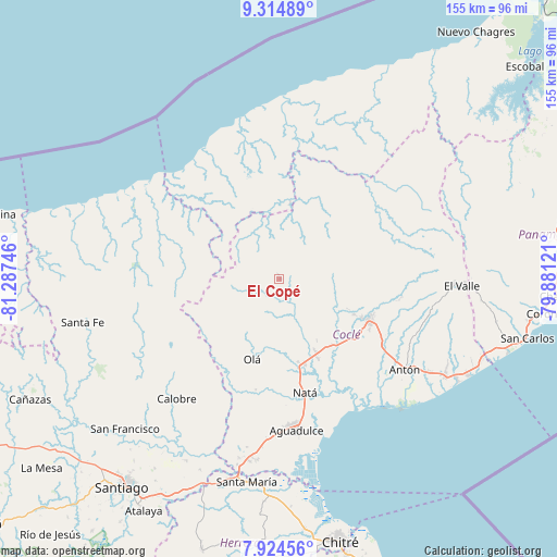
El Copé GPS coordinates[2]
8° 37' 13.296" North, 80° 35' 3.588" West
| Map corner | latitude | longitude |
|---|---|---|
| Upper-left | 9.31489°, | -81.28746° |
| Center: | 8.62036°, | -80.58433° |
| Lower-right: | 7.92456°, | -79.88121° |
| Map W x H: | 154.6×154.6 km | = 96.1×96.1mi |
| max Lat: | 9.60898° ⇑34.9% North |
| El Copé: | 8.62036° |
| min Lat: | ⇓65.1% South 7.26534° |
| min Long | El Copé | max Long |
| -82.91275° | -80.58433° | -77.38965° |
| W 50.1%⇐ | ⇒49.9% E |
Elevation
Elevation of El Copé is 419 m = 1375 ft, and this is 246.9 m = 810 ft above average elevation for this country.
| Max E: |
2103 m = 6900 ft | 11.2% |
| El Copé | 419 m 1375 ft | |
| Avg. | 172.1 m = 565 ft | |
Min E: |
-1 m = -3 ft | 88.8% |
See also: Panama elevation on elevation.city.
Geographical zone
El Copé is located in North Torrid zone (between Equator and Tropic of Cancer). Distance of Equator is 958.5 km =595.6 mi to South.| Distance of | km | miles | from El Copé |
|---|---|---|---|
| North Pole | 9048.6 | 5622.5 | to North |
| Arctic Circle | 6442.7 | 4003.3 | to North |
| Tropic Cancer | 1647.4 | 1023.6 | to North |
| Equator | 958.5 | 595.6 | to South |


Nearby cities:
15 places around El Copé: (largest is in red/bold)
• Bella Vista
21.3 km =13.2 mi,  113°
113°
• Cañaveral
20.6 km =12.8 mi,  123°
123°
• Coclecito
21.1 km =13.1 mi,  8°
8°
• El Copé
22.8 km =14.2 mi,  207°
207°
• El Potrero
13.3 km =8.3 mi,  145°
145°
• Guzman
11.2 km =7 mi,  179°
179°
• La Candelaria
22.7 km =14.1 mi, 152°
• La Pintada
15.8 km =9.8 mi,  101°
101°
• Las Minas
21 km =13 mi,  83°
83°
• Las Sabanas
11.4 km =7.1 mi,  247°
247°
• Llano Grande
16.2 km =10.1 mi, 82°
• Los Uveros
23.2 km =14.4 mi, 116°
• Machuca
4 km =2.5 mi,  87°
87°
• Nuestro Amo
19.5 km =12.1 mi, 181°
• Piedras Gordas
8.4 km =5.2 mi, 76°
Sources, notices
• [Note1] Compared only with cities in Panama existing in our database
• [Src1] Map data: © OpenStreetMap contributors (CC-BY-SA)
• [Src2] Other city data from geonames.org with taken over terms of usage.
• [Src3] Geographical zone / Annual Mean Temperature by Robert A. Rohde @ Wikipedia
