Churubé Abajo geodata
Churubé Abajo (Coclé) is a populated place; located in Panama in America/Panama (GMT-5) time zone. With population of 774 people, there are 331 cities with bigger population in this country. Compared to other cities in Panama, 57.4% of cities are located further ↑North; 52% of cities are located further ←West and 79.6% of cities have higher elevation than Churubé Abajo. Note1


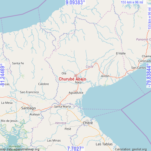
Churubé Abajo GPS coordinates[2]
8° 23' 56.004" North, 80° 32' 29.616" West
| Map corner | latitude | longitude |
|---|---|---|
| Upper-left | 9.09383°, | -81.24469° |
| Center: | 8.39889°, | -80.54156° |
| Lower-right: | 7.7027°, | -79.83844° |
| Map W x H: | 154.7×154.7 km | = 96.1×96.1mi |
| max Lat: | 9.60898° ⇑57.4% North |
| Churubé Abajo: | 8.39889° |
| min Lat: | ⇓42.6% South 7.26534° |
| min Long | Churubé Abajo | max Long |
| -82.91275° | -80.54156° | -77.38965° |
| W 52%⇐ | ⇒48% E |
Elevation
Elevation of Churubé Abajo is 24 m = 79 ft, and this is 148.1 m = 486 ft below average elevation for this country.
| Max E: |
2103 m = 6900 ft | 79.6% |
| Avg. | 172.1 m = 565 ft | |
| Churubé Abajo | 24 m = 79 ft | |
Min E: |
-1 m = -3 ft | 20.4% |
See also: Panama elevation on elevation.city.
Geographical zone
Churubé Abajo is located in North Torrid zone (between Equator and Tropic of Cancer). Distance of Equator is 933.9 km =580.3 mi to South.| Distance of | km | miles | from Churubé Abajo |
|---|---|---|---|
| North Pole | 9073.2 | 5637.8 | to North |
| Arctic Circle | 6467.3 | 4018.6 | to North |
| Tropic Cancer | 1672 | 1038.9 | to North |
| Equator | 933.9 | 580.3 | to South |


Nearby cities:
15 places around Churubé Abajo: (largest is in red/bold)
• Barranco Colorado
10.4 km =6.5 mi,  264°
264°
• Capellanía
11.2 km =7 mi,  187°
187°
• Ciruelito
11.7 km =7.3 mi,  59°
59°
• Coclé
13.9 km =8.6 mi, 62°
• El Caño
2.6 km =1.6 mi,  82°
82°
• El Congo
13.8 km =8.6 mi,  72°
72°
• El Cortezo
7.8 km =4.8 mi,  220°
220°
• El Potrero
13.9 km =8.6 mi,  11°
11°
• La Candelaria
7.2 km =4.5 mi,  51°
51°
• Las Guabas
10.5 km =6.5 mi,  97°
97°
• Natá
7.8 km =4.8 mi,  162°
162°
• Nuestro Amo
7.3 km =4.5 mi,  314°
314°
• Olá
12.3 km =7.6 mi,  280°
280°
• Río Grande
7 km =4.3 mi, 63°
• Toza
12.4 km =7.7 mi,  241°
241°
Sources, notices
• [Note1] Compared only with cities in Panama existing in our database
• [Src1] Map data: © OpenStreetMap contributors (CC-BY-SA)
• [Src2] Other city data from geonames.org with taken over terms of usage.
• [Src3] Geographical zone / Annual Mean Temperature by Robert A. Rohde @ Wikipedia
