Natá geodata
Natá (Coclé) is a seat of a second-order administrative division; located in Panama in America/Panama (GMT-5) time zone. With population of 5,470 people, there are 64 cities with bigger population in this country. Compared to other cities in Panama, 64.7% of cities are located further ↑North; 52.6% of cities are located further ←West and 85.5% of cities have higher elevation than Natá. Note1


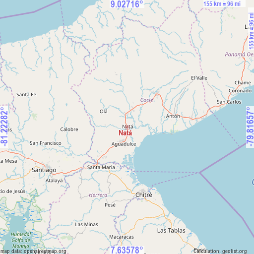
Natá GPS coordinates[2]
8° 19' 55.524" North, 80° 31' 10.884" West
| Map corner | latitude | longitude |
|---|---|---|
| Upper-left | 9.02716°, | -81.22282° |
| Center: | 8.33209°, | -80.51969° |
| Lower-right: | 7.63578°, | -79.81657° |
| Map W x H: | 154.7×154.7 km | = 96.1×96.1mi |
| max Lat: | 9.60898° ⇑64.7% North |
| Natá: | 8.33209° |
| min Lat: | ⇓35.3% South 7.26534° |
| min Long | Natá | max Long |
| -82.91275° | -80.51969° | -77.38965° |
| W 52.6%⇐ | ⇒47.4% E |
Elevation
Elevation of Natá is 17 m = 56 ft, and this is 155.1 m = 509 ft below average elevation for this country.
| Max E: |
2103 m = 6900 ft | 85.5% |
| Avg. | 172.1 m = 565 ft | |
| Natá | 17 m = 56 ft | |
Min E: |
-1 m = -3 ft | 14.5% |
See also: Panama elevation on elevation.city.
Geographical zone
Natá is located in North Torrid zone (between Equator and Tropic of Cancer). Distance of Equator is 926.4 km =575.6 mi to South.| Distance of | km | miles | from Natá |
|---|---|---|---|
| North Pole | 9080.6 | 5642.4 | to North |
| Arctic Circle | 6474.7 | 4023.2 | to North |
| Tropic Cancer | 1679.5 | 1043.6 | to North |
| Equator | 926.4 | 575.6 | to South |


Nearby cities:
15 places around Natá: (largest is in red/bold)
• Aguadulce
10.4 km =6.5 mi,  196°
196°
• Barranco Colorado
14.2 km =8.8 mi,  296°
296°
• Capellanía
5.4 km =3.4 mi,  226°
226°
• Churubé Abajo
7.8 km =4.8 mi,  342°
342°
• Ciruelito
15.5 km =9.6 mi,  29°
29°
• El Caño
7.8 km =4.8 mi,  1°
1°
• El Congo
15.8 km =9.8 mi,  42°
42°
• El Cortezo
7.6 km =4.7 mi,  281°
281°
• El Cristo
14.4 km =8.9 mi, 230°
• La Candelaria
12.3 km =7.6 mi,  15°
15°
• Las Guabas
10 km =6.2 mi,  53°
53°
• Nuestro Amo
14.7 km =9.1 mi,  328°
328°
• Pocrí
8.9 km =5.5 mi, 202°
• Río Grande
11.2 km =7 mi, 20°
• Toza
13.3 km =8.3 mi, 276°
Sources, notices
• [Note1] Compared only with cities in Panama existing in our database
• [Src1] Map data: © OpenStreetMap contributors (CC-BY-SA)
• [Src2] Other city data from geonames.org with taken over terms of usage.
• [Src3] Geographical zone / Annual Mean Temperature by Robert A. Rohde @ Wikipedia
