El Cortezo geodata
El Cortezo (Coclé) is a populated place; located in Panama in America/Panama (GMT-5) time zone. With population of 1,157 people, there are 210 cities with bigger population in this country. Compared to other cities in Panama, 63.4% of cities are located further ↑North; 50.1% of cities are located further →East and 57.3% of cities have higher elevation than El Cortezo. Note1


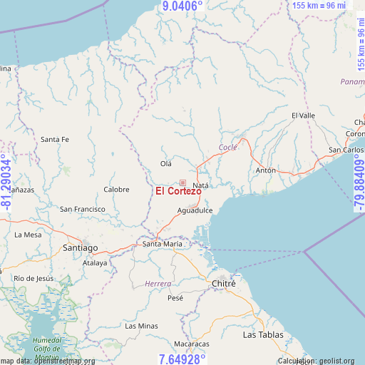
El Cortezo GPS coordinates[2]
8° 20' 44.016" North, 80° 35' 13.956" West
| Map corner | latitude | longitude |
|---|---|---|
| Upper-left | 9.0406°, | -81.29034° |
| Center: | 8.34556°, | -80.58721° |
| Lower-right: | 7.64928°, | -79.88409° |
| Map W x H: | 154.7×154.7 km | = 96.1×96.1mi |
| max Lat: | 9.60898° ⇑63.4% North |
| El Cortezo: | 8.34556° |
| min Lat: | ⇓36.6% South 7.26534° |
| min Long | El Cortezo | max Long |
| -82.91275° | -80.58721° | -77.38965° |
| W 49.9%⇐ | ⇒50.1% E |
Elevation
Elevation of El Cortezo is 59 m = 194 ft, and this is 113.1 m = 371 ft below average elevation for this country.
| Max E: |
2103 m = 6900 ft | 57.3% |
| Avg. | 172.1 m = 565 ft | |
| El Cortezo | 59 m = 194 ft | |
Min E: |
-1 m = -3 ft | 42.7% |
See also: Panama elevation on elevation.city.
Geographical zone
El Cortezo is located in North Torrid zone (between Equator and Tropic of Cancer). Distance of Equator is 927.9 km =576.6 mi to South.| Distance of | km | miles | from El Cortezo |
|---|---|---|---|
| North Pole | 9079.1 | 5641.5 | to North |
| Arctic Circle | 6473.2 | 4022.3 | to North |
| Tropic Cancer | 1678 | 1042.7 | to North |
| Equator | 927.9 | 576.6 | to South |


Nearby cities:
15 places around El Cortezo: (largest is in red/bold)
• Aguadulce
12.4 km =7.7 mi,  158°
158°
• Barranco Colorado
7.2 km =4.5 mi,  312°
312°
• Capellanía
6.3 km =3.9 mi,  145°
145°
• Churubé Abajo
7.8 km =4.8 mi,  40°
40°
• El Caño
9.9 km =6.2 mi,  50°
50°
• El Copé
14.4 km =8.9 mi,  315°
315°
• El Cristo
11.2 km =7 mi,  199°
199°
• La Candelaria
14.9 km =9.3 mi, 45°
• La Laguna
15.7 km =9.8 mi,  267°
267°
• Natá
7.6 km =4.7 mi,  101°
101°
• Nuestro Amo
11 km =6.8 mi,  358°
358°
• Olá
10.7 km =6.6 mi, 318°
• Pocrí
10.5 km =6.5 mi, 157°
• Río Grande
14.5 km =9 mi, 51°
• Toza
5.8 km =3.6 mi, 269°
Sources, notices
• [Note1] Compared only with cities in Panama existing in our database
• [Src1] Map data: © OpenStreetMap contributors (CC-BY-SA)
• [Src2] Other city data from geonames.org with taken over terms of usage.
• [Src3] Geographical zone / Annual Mean Temperature by Robert A. Rohde @ Wikipedia
