Calzada Larga geodata
Calzada Larga (Panamá) is a populated place; located in Panama in America/Panama (GMT-5) time zone. With population of 1,656 people, there are 143 cities with bigger population in this country. Compared to other cities in Panama, 90.2% of cities are located further ↓South; 85.9% of cities are located further ←West and 61.3% of cities have lower elevation than Calzada Larga. Note1


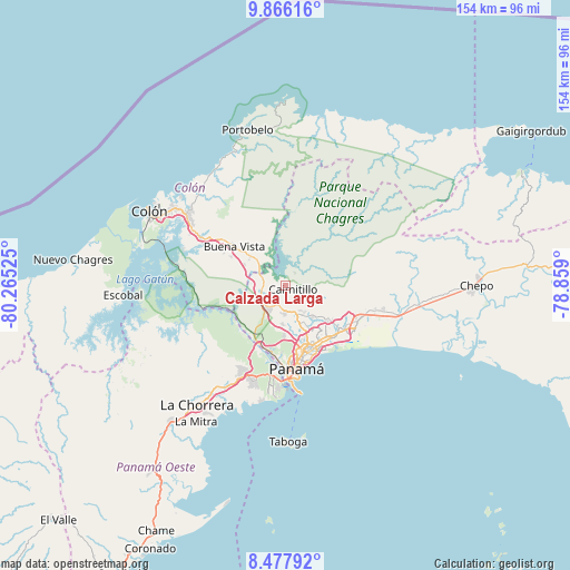
Calzada Larga GPS coordinates[2]
9° 10' 21.792" North, 79° 33' 43.632" West
| Map corner | latitude | longitude |
|---|---|---|
| Upper-left | 9.86616°, | -80.26525° |
| Center: | 9.17272°, | -79.56212° |
| Lower-right: | 8.47792°, | -78.859° |
| Map W x H: | 154.4×154.4 km | = 95.9×95.9mi |
| max Lat: | 9.60898° ⇑9.8% North |
| Calzada Larga: | 9.17272° |
| min Lat: | ⇓90.2% South 7.26534° |
| min Long | Calzada Larga | max Long |
| -82.91275° | -79.56212° | -77.38965° |
| W 85.9%⇐ | ⇒14.1% E |
Elevation
Elevation of Calzada Larga is 112 m = 367 ft, and this is 60.1 m = 197 ft below average elevation for this country.
| Max E: |
2103 m = 6900 ft | 38.7% |
| Avg. | 172.1 m = 565 ft | |
| Calzada Larga | 112 m = 367 ft | |
Min E: |
-1 m = -3 ft | 61.3% |
See also: Panama elevation on elevation.city.
Geographical zone
Calzada Larga is located in North Torrid zone (between Equator and Tropic of Cancer). Distance of Equator is 1019.9 km =633.7 mi to South.| Distance of | km | miles | from Calzada Larga |
|---|---|---|---|
| North Pole | 8987.2 | 5584.4 | to North |
| Arctic Circle | 6381.3 | 3965.2 | to North |
| Tropic Cancer | 1586 | 985.5 | to North |
| Equator | 1019.9 | 633.7 | to South |


Nearby cities:
15 places around Calzada Larga: (largest is in red/bold)
• Alcalde Díaz
5.9 km =3.7 mi,  173°
173°
• Caimitillo
3.1 km =1.9 mi,  127°
127°
• Chilibre
6.9 km =4.3 mi,  249°
249°
• El Valle de la Unión
12.8 km =8 mi,  303°
303°
• Gatuncillo
12.3 km =7.6 mi,  309°
309°
• Gonzalillo
10.1 km =6.3 mi,  152°
152°
• La Cabima
6.6 km =4.1 mi,  155°
155°
• Las Cumbres
10 km =6.2 mi, 158°
• Mocambo Arriba
11 km =6.8 mi,  183°
183°
• Nuevo San Juan
12.7 km =7.9 mi, 295°
• Nuevo Vigía
9.2 km =5.7 mi,  327°
327°
• Palenque
13.6 km =8.5 mi,  286°
286°
• San Antonio
1.6 km =1 mi,  89°
89°
• San Vicente
7.6 km =4.7 mi,  210°
210°
• Villa Unida
7.1 km =4.4 mi,  284°
284°
Sources, notices
• [Note1] Compared only with cities in Panama existing in our database
• [Src1] Map data: © OpenStreetMap contributors (CC-BY-SA)
• [Src2] Other city data from geonames.org with taken over terms of usage.
• [Src3] Geographical zone / Annual Mean Temperature by Robert A. Rohde @ Wikipedia
