Sajalices geodata
Sajalices (Panamá) is a populated place; located in Panama in America/Panama (GMT-5) time zone. With population of 945 people, there are 270 cities with bigger population in this country. Compared to other cities in Panama, 69.1% of cities are located further ↓South; 77.7% of cities are located further ←West and 58.1% of cities have higher elevation than Sajalices. Note1


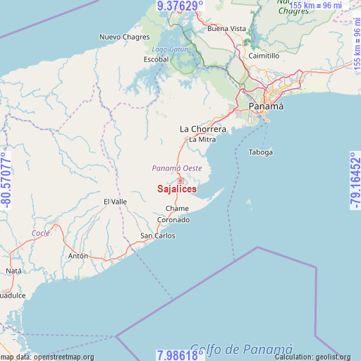
Sajalices GPS coordinates[2]
8° 40' 54.768" North, 79° 52' 3.504" West
| Map corner | latitude | longitude |
|---|---|---|
| Upper-left | 9.37629°, | -80.57077° |
| Center: | 8.68188°, | -79.86764° |
| Lower-right: | 7.98618°, | -79.16452° |
| Map W x H: | 154.6×154.6 km | = 96.1×96.1mi |
| max Lat: | 9.60898° ⇑30.9% North |
| Sajalices: | 8.68188° |
| min Lat: | ⇓69.1% South 7.26534° |
| min Long | Sajalices | max Long |
| -82.91275° | -79.86764° | -77.38965° |
| W 77.7%⇐ | ⇒22.3% E |
Elevation
Elevation of Sajalices is 58 m = 190 ft, and this is 114.1 m = 374 ft below average elevation for this country.
| Max E: |
2103 m = 6900 ft | 58.1% |
| Avg. | 172.1 m = 565 ft | |
| Sajalices | 58 m = 190 ft | |
Min E: |
-1 m = -3 ft | 41.9% |
See also: Panama elevation on elevation.city.
Geographical zone
Sajalices is located in North Torrid zone (between Equator and Tropic of Cancer). Distance of Equator is 965.3 km =599.8 mi to South.| Distance of | km | miles | from Sajalices |
|---|---|---|---|
| North Pole | 9041.7 | 5618.3 | to North |
| Arctic Circle | 6435.8 | 3999 | to North |
| Tropic Cancer | 1640.6 | 1019.4 | to North |
| Equator | 965.3 | 599.8 | to South |


Nearby cities:
15 places around Sajalices: (largest is in red/bold)
• Bejuco
9.4 km =5.8 mi,  195°
195°
• Buenos Aires
10.4 km =6.5 mi,  237°
237°
• Capira
8.4 km =5.2 mi,  350°
350°
• Cermeño
6.7 km =4.2 mi,  13°
13°
• Cerro Campana
5.6 km =3.5 mi,  299°
299°
• Chame
11.8 km =7.3 mi,  189°
189°
• El Alto de Capira
6 km =3.7 mi,  338°
338°
• El Espavé
2.4 km =1.5 mi, 201°
• El Líbano
8.1 km =5 mi,  153°
153°
• La Cresta
5 km =3.1 mi, 199°
• Llano Grande
9.2 km =5.7 mi,  229°
229°
• Llano de Santa Rosa
8.8 km =5.5 mi,  3°
3°
• Lídice
8.8 km =5.5 mi,  328°
328°
• Villa Carmen
12.9 km =8 mi,  359°
359°
• Villa Rosario
10.3 km =6.4 mi, 355°
Sources, notices
• [Note1] Compared only with cities in Panama existing in our database
• [Src1] Map data: © OpenStreetMap contributors (CC-BY-SA)
• [Src2] Other city data from geonames.org with taken over terms of usage.
• [Src3] Geographical zone / Annual Mean Temperature by Robert A. Rohde @ Wikipedia
