Cascabel geodata
Cascabel (Ngöbe-Buglé) is a seat of a third-order administrative division; located in Panama in America/Panama (GMT-5) time zone. In our database, there are 694 cities with bigger population. Compared to other cities in Panama, 55.9% of cities are located further ↓South; 77.1% of cities are located further →East and 99% of cities have lower elevation than Cascabel. Note1


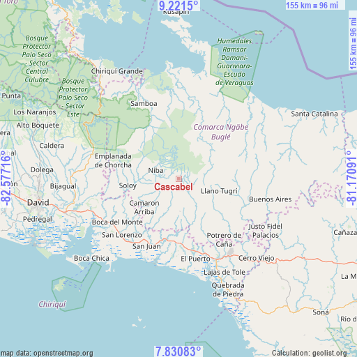
Cascabel GPS coordinates[2]
8° 31' 36.48" North, 81° 52' 26.508" West
| Map corner | latitude | longitude |
|---|---|---|
| Upper-left | 9.2215°, | -82.57716° |
| Center: | 8.5268°, | -81.87403° |
| Lower-right: | 7.83083°, | -81.17091° |
| Map W x H: | 154.6×154.6 km | = 96.1×96.1mi |
| max Lat: | 9.60898° ⇑44.1% North |
| Cascabel: | 8.5268° |
| min Lat: | ⇓55.9% South 7.26534° |
| min Long | Cascabel | max Long |
| -82.91275° | -81.87403° | -77.38965° |
| W 22.9%⇐ | ⇒77.1% E |
Elevation
Elevation of Cascabel is 1188 m = 3898 ft, and this is 1015.9 m = 3333 ft above average elevation for this country.
| Max E: |
2103 m = 6900 ft | 1% |
| Cascabel | 1188 m 3898 ft | |
| Avg. | 172.1 m = 565 ft | |
Min E: |
-1 m = -3 ft | 99% |
See also: Panama elevation on elevation.city.
Geographical zone
Cascabel is located in North Torrid zone (between Equator and Tropic of Cancer). Distance of Equator is 948.1 km =589.1 mi to South.| Distance of | km | miles | from Cascabel |
|---|---|---|---|
| North Pole | 9059 | 5629 | to North |
| Arctic Circle | 6453.1 | 4009.8 | to North |
| Tropic Cancer | 1657.8 | 1030.1 | to North |
| Equator | 948.1 | 589.1 | to South |


Nearby cities:
15 places around Cascabel: (largest is in red/bold)
• Boca de Balsa
17.3 km =10.7 mi,  271°
271°
• Buabidi
20.2 km =12.6 mi,  106°
106°
• Camarón Arriba
20.7 km =12.9 mi,  219°
219°
• Cerro Banco
18.9 km =11.7 mi,  246°
246°
• Cuoronte
19.1 km =11.9 mi,  30°
30°
• Hato Chami
14.6 km =9.1 mi,  129°
129°
• Hato Culantro
6.7 km =4.2 mi,  164°
164°
• Hato Jobo
15.1 km =9.4 mi,  185°
185°
• Hato Juli
19.9 km =12.4 mi,  170°
170°
• Hato Pilón
14.3 km =8.9 mi,  176°
176°
• Mirones
16.7 km =10.4 mi,  78°
78°
• Piedra Roja
14.8 km =9.2 mi,  70°
70°
• Quebrada Canoa
14.4 km =8.9 mi,  136°
136°
• Quebrada de Loro
19.5 km =12.1 mi,  197°
197°
• Salto Dupí
19.5 km =12.1 mi, 184°
Sources, notices
• [Note1] Compared only with cities in Panama existing in our database
• [Src1] Map data: © OpenStreetMap contributors (CC-BY-SA)
• [Src2] Other city data from geonames.org with taken over terms of usage.
• [Src3] Geographical zone / Annual Mean Temperature by Robert A. Rohde @ Wikipedia
