Piedra Roja geodata
Piedra Roja (Ngöbe-Buglé) is a seat of a third-order administrative division; located in Panama in America/Panama (GMT-5) time zone. In our database, there are 694 cities with bigger population. Compared to other cities in Panama, 61.6% of cities are located further ↓South; 74.1% of cities are located further →East and 95.7% of cities have lower elevation than Piedra Roja. Note1


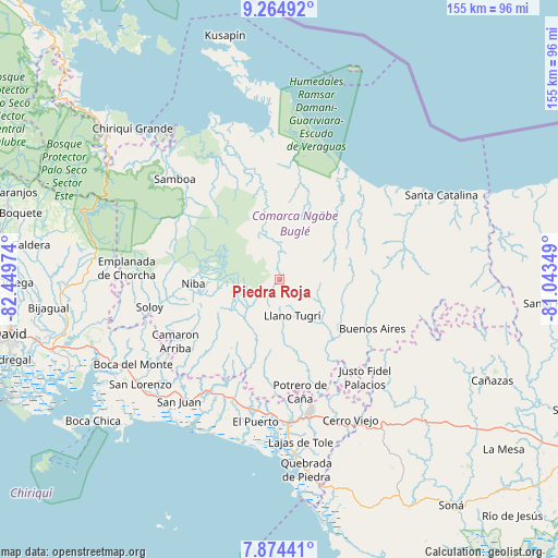
Piedra Roja GPS coordinates[2]
8° 34' 13.08" North, 81° 44' 47.796" West
| Map corner | latitude | longitude |
|---|---|---|
| Upper-left | 9.26492°, | -82.44974° |
| Center: | 8.5703°, | -81.74661° |
| Lower-right: | 7.87441°, | -81.04349° |
| Map W x H: | 154.6×154.6 km | = 96.1×96.1mi |
| max Lat: | 9.60898° ⇑38.4% North |
| Piedra Roja: | 8.5703° |
| min Lat: | ⇓61.6% South 7.26534° |
| min Long | Piedra Roja | max Long |
| -82.91275° | -81.74661° | -77.38965° |
| W 25.9%⇐ | ⇒74.1% E |
Elevation
Elevation of Piedra Roja is 788 m = 2585 ft, and this is 615.9 m = 2021 ft above average elevation for this country.
| Max E: |
2103 m = 6900 ft | 4.3% |
| Piedra Roja | 788 m 2585 ft | |
| Avg. | 172.1 m = 565 ft | |
Min E: |
-1 m = -3 ft | 95.7% |
See also: Panama elevation on elevation.city.
Geographical zone
Piedra Roja is located in North Torrid zone (between Equator and Tropic of Cancer). Distance of Equator is 952.9 km =592.1 mi to South.| Distance of | km | miles | from Piedra Roja |
|---|---|---|---|
| North Pole | 9054.1 | 5626 | to North |
| Arctic Circle | 6448.2 | 4006.7 | to North |
| Tropic Cancer | 1653 | 1027.1 | to North |
| Equator | 952.9 | 592.1 | to South |


Nearby cities:
15 places around Piedra Roja: (largest is in red/bold)
• Buabidi
11.9 km =7.4 mi,  153°
153°
• Cascabel
14.8 km =9.2 mi,  250°
250°
• Chichica
24.3 km =15.1 mi,  158°
158°
• Cuoronte
12.4 km =7.7 mi,  339°
339°
• Hato Chami
14.4 km =8.9 mi,  191°
191°
• Hato Culantro
16.6 km =10.3 mi,  227°
227°
• Hato Pilón
23.2 km =14.4 mi,  214°
214°
• Llano Junco
24.2 km =15 mi,  182°
182°
• Llano Ñopo
21.9 km =13.6 mi,  139°
139°
• Maraca
22 km =13.7 mi,  174°
174°
• Mirones
2.7 km =1.7 mi,  121°
121°
• Peña Blanca
14.2 km =8.8 mi, 148°
• Peña Prieta
22.4 km =13.9 mi, 171°
• Quebrada Canoa
15.8 km =9.8 mi, 194°
• Tebujo
20.4 km =12.7 mi, 172°
Sources, notices
• [Note1] Compared only with cities in Panama existing in our database
• [Src1] Map data: © OpenStreetMap contributors (CC-BY-SA)
• [Src2] Other city data from geonames.org with taken over terms of usage.
• [Src3] Geographical zone / Annual Mean Temperature by Robert A. Rohde @ Wikipedia
