Cuoronte geodata
Cuoronte (Ngöbe-Buglé) is a seat of a third-order administrative division; located in Panama in America/Panama (GMT-5) time zone. In our database, there are 694 cities with bigger population. Compared to other cities in Panama, 69% of cities are located further ↓South; 74.9% of cities are located further →East and 88% of cities have lower elevation than Cuoronte. Note1


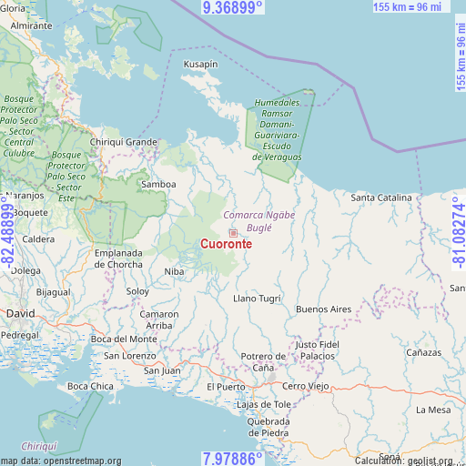
Cuoronte GPS coordinates[2]
8° 40' 28.452" North, 81° 47' 9.096" West
| Map corner | latitude | longitude |
|---|---|---|
| Upper-left | 9.36899°, | -82.48899° |
| Center: | 8.67457°, | -81.78586° |
| Lower-right: | 7.97886°, | -81.08274° |
| Map W x H: | 154.6×154.6 km | = 96.1×96.1mi |
| max Lat: | 9.60898° ⇑31% North |
| Cuoronte: | 8.67457° |
| min Lat: | ⇓69% South 7.26534° |
| min Long | Cuoronte | max Long |
| -82.91275° | -81.78586° | -77.38965° |
| W 25.1%⇐ | ⇒74.9% E |
Elevation
Elevation of Cuoronte is 396 m = 1299 ft, and this is 223.9 m = 735 ft above average elevation for this country.
| Max E: |
2103 m = 6900 ft | 12% |
| Cuoronte | 396 m 1299 ft | |
| Avg. | 172.1 m = 565 ft | |
Min E: |
-1 m = -3 ft | 88% |
See also: Panama elevation on elevation.city.
Geographical zone
Cuoronte is located in North Torrid zone (between Equator and Tropic of Cancer). Distance of Equator is 964.5 km =599.3 mi to South.| Distance of | km | miles | from Cuoronte |
|---|---|---|---|
| North Pole | 9042.5 | 5618.7 | to North |
| Arctic Circle | 6436.7 | 3999.6 | to North |
| Tropic Cancer | 1641.4 | 1019.9 | to North |
| Equator | 964.5 | 599.3 | to South |


Nearby cities:
15 places around Cuoronte: (largest is in red/bold)
• Bisira
25.7 km =16 mi,  343°
343°
• Boca de Balsa
31.4 km =19.5 mi,  239°
239°
• Boca del Río Chiriquí
30.1 km =18.7 mi,  51°
51°
• Buabidi
24.2 km =15 mi,  156°
156°
• Cascabel
19.1 km =11.9 mi,  210°
210°
• Hato Chami
25.8 km =16 mi,  176°
176°
• Hato Culantro
24.2 km =15 mi,  198°
198°
• Hato Pilón
32 km =19.9 mi, 195°
• Kankintú
19 km =11.8 mi,  350°
350°
• Mirones
14.6 km =9.1 mi,  153°
153°
• Nutiví
22.6 km =14 mi, 344°
• Peña Blanca
26.4 km =16.4 mi, 153°
• Piedra Roja
12.4 km =7.7 mi, 159°
• Quebrada Canoa
26.8 km =16.7 mi, 179°
• Quebrada Tula
29.6 km =18.4 mi,  308°
308°
Sources, notices
• [Note1] Compared only with cities in Panama existing in our database
• [Src1] Map data: © OpenStreetMap contributors (CC-BY-SA)
• [Src2] Other city data from geonames.org with taken over terms of usage.
• [Src3] Geographical zone / Annual Mean Temperature by Robert A. Rohde @ Wikipedia
