El Cañafístulo geodata
El Cañafístulo (Los Santos) is a seat of a third-order administrative division; located in Panama in America/Panama (GMT-5) time zone. With population of 141 people, there are 635 cities with bigger population in this country. Compared to other cities in Panama, 97% of cities are located further ↑North; 66% of cities are located further ←West and 70.2% of cities have lower elevation than El Cañafístulo. Note1


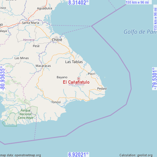
El Cañafístulo GPS coordinates[2]
7° 37' 3.648" North, 80° 13' 59.592" West
| Map corner | latitude | longitude |
|---|---|---|
| Upper-left | 8.31402°, | -80.93635° |
| Center: | 7.61768°, | -80.23322° |
| Lower-right: | 6.92021°, | -79.5301° |
| Map W x H: | 155×155 km | = 96.3×96.3mi |
| max Lat: | 9.60898° ⇑97% North |
| El Cañafístulo: | 7.61768° |
| min Lat: | ⇓3% South 7.26534° |
| min Long | El Cañafístul | max Long |
| -82.91275° | -80.23322° | -77.38965° |
| W 66%⇐ | ⇒34% E |
Elevation
Elevation of El Cañafístulo is 157 m = 515 ft, and this is 15.1 m = 50 ft below average elevation for this country.
| Max E: |
2103 m = 6900 ft | 29.8% |
| Avg. | 172.1 m = 565 ft | |
| El Cañafístulo | 157 m = 515 ft | |
Min E: |
-1 m = -3 ft | 70.2% |
See also: Panama elevation on elevation.city.
Geographical zone
El Cañafístulo is located in North Torrid zone (between Equator and Tropic of Cancer). Distance of Equator is 847 km =526.3 mi to South.| Distance of | km | miles | from El Cañafístulo |
|---|---|---|---|
| North Pole | 9160.1 | 5691.8 | to North |
| Arctic Circle | 6554.2 | 4072.6 | to North |
| Tropic Cancer | 1758.9 | 1092.9 | to North |
| Equator | 847 | 526.3 | to South |


Nearby cities:
15 places around El Cañafístulo: (largest is in red/bold)
• Bajo Corral
3.3 km =2.1 mi,  243°
243°
• El Muñoz
11.7 km =7.3 mi,  303°
303°
• El Pedregoso
13.3 km =8.3 mi,  308°
308°
• La Laja
12.8 km =8 mi,  350°
350°
• La Miel
12.2 km =7.6 mi, 238°
• La Palma
8.9 km =5.5 mi,  27°
27°
• Lajamina
11.7 km =7.3 mi,  107°
107°
• Oria Arriba
12.9 km =8 mi,  166°
166°
• Paraíso
10.9 km =6.8 mi,  46°
46°
• Paritilla
6.8 km =4.2 mi,  79°
79°
• Peña Blanca
12.6 km =7.8 mi,  333°
333°
• Pocrí
13.1 km =8.1 mi,  69°
69°
• San José
6.4 km =4 mi, 348°
• Valle Rico
13 km =8.1 mi,  271°
271°
• Vallerriquito
9.5 km =5.9 mi, 272°
Sources, notices
• [Note1] Compared only with cities in Panama existing in our database
• [Src1] Map data: © OpenStreetMap contributors (CC-BY-SA)
• [Src2] Other city data from geonames.org with taken over terms of usage.
• [Src3] Geographical zone / Annual Mean Temperature by Robert A. Rohde @ Wikipedia
