Lajamina geodata
Lajamina (Los Santos) is a seat of a third-order administrative division; located in Panama in America/Panama (GMT-5) time zone. With population of 330 people, there are 547 cities with bigger population in this country. Compared to other cities in Panama, 97.2% of cities are located further ↑North; 69.9% of cities are located further ←West and 60.3% of cities have higher elevation than Lajamina. Note1


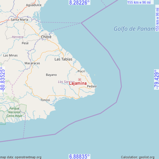
Lajamina GPS coordinates[2]
7° 35' 9.132" North, 80° 7' 55.632" West
| Map corner | latitude | longitude |
|---|---|---|
| Upper-left | 8.28226°, | -80.83525° |
| Center: | 7.58587°, | -80.13212° |
| Lower-right: | 6.88835°, | -79.429° |
| Map W x H: | 155×155 km | = 96.3×96.3mi |
| max Lat: | 9.60898° ⇑97.2% North |
| Lajamina: | 7.58587° |
| min Lat: | ⇓2.8% South 7.26534° |
| min Long | Lajamina | max Long |
| -82.91275° | -80.13212° | -77.38965° |
| W 69.9%⇐ | ⇒30.1% E |
Elevation
Elevation of Lajamina is 51 m = 167 ft, and this is 121.1 m = 397 ft below average elevation for this country.
| Max E: |
2103 m = 6900 ft | 60.3% |
| Avg. | 172.1 m = 565 ft | |
| Lajamina | 51 m = 167 ft | |
Min E: |
-1 m = -3 ft | 39.7% |
See also: Panama elevation on elevation.city.
Geographical zone
Lajamina is located in North Torrid zone (between Equator and Tropic of Cancer). Distance of Equator is 843.5 km =524.1 mi to South.| Distance of | km | miles | from Lajamina |
|---|---|---|---|
| North Pole | 9163.6 | 5694 | to North |
| Arctic Circle | 6557.7 | 4074.8 | to North |
| Tropic Cancer | 1762.4 | 1095.1 | to North |
| Equator | 843.5 | 524.1 | to South |


Nearby cities:
15 places around Lajamina: (largest is in red/bold)
• Bajo Corral
14.3 km =8.9 mi,  278°
278°
• Cañas
21.3 km =13.2 mi,  223°
223°
• El Cañafístulo
11.7 km =7.3 mi,  287°
287°
• La Laja
20.9 km =13 mi,  320°
320°
• La Palma
13.4 km =8.3 mi,  328°
328°
• Los Asientos
7.7 km =4.8 mi,  182°
182°
• Mariabé
7.3 km =4.5 mi,  92°
92°
• Oria Arriba
12.1 km =7.5 mi, 222°
• Paraíso
11.5 km =7.1 mi,  344°
344°
• Paritilla
6.5 km =4 mi, 316°
• Pedasí
13.1 km =8.1 mi,  118°
118°
• Pocrí
8.1 km =5 mi,  8°
8°
• San José
15.8 km =9.8 mi,  308°
308°
• Sesteadero
21.3 km =13.2 mi, 322°
• Vallerriquito
21.1 km =13.1 mi, 280°
Sources, notices
• [Note1] Compared only with cities in Panama existing in our database
• [Src1] Map data: © OpenStreetMap contributors (CC-BY-SA)
• [Src2] Other city data from geonames.org with taken over terms of usage.
• [Src3] Geographical zone / Annual Mean Temperature by Robert A. Rohde @ Wikipedia
