Caimito geodata
Caimito (Chiriquí) is a populated place; located in Panama in America/Panama (GMT-5) time zone. With population of 1,066 people, there are 235 cities with bigger population in this country. Compared to other cities in Panama, 58.3% of cities are located further ↓South; 84.8% of cities are located further →East and 75.9% of cities have lower elevation than Caimito. Note1


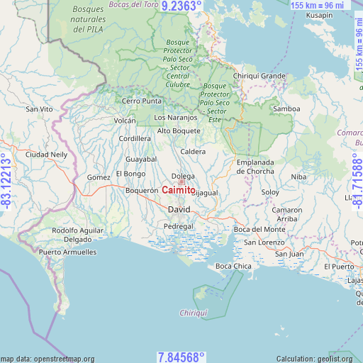
Caimito GPS coordinates[2]
8° 32' 29.832" North, 82° 25' 8.4" West
| Map corner | latitude | longitude |
|---|---|---|
| Upper-left | 9.2363°, | -83.12213° |
| Center: | 8.54162°, | -82.419° |
| Lower-right: | 7.84568°, | -81.71588° |
| Map W x H: | 154.6×154.6 km | = 96.1×96.1mi |
| max Lat: | 9.60898° ⇑41.7% North |
| Caimito: | 8.54162° |
| min Lat: | ⇓58.3% South 7.26534° |
| min Long | Caimito | max Long |
| -82.91275° | -82.419° | -77.38965° |
| W 15.2%⇐ | ⇒84.8% E |
Elevation
Elevation of Caimito is 207 m = 679 ft, and this is 34.9 m = 115 ft above average elevation for this country.
| Max E: |
2103 m = 6900 ft | 24.1% |
| Caimito | 207 m 679 ft | |
| Avg. | 172.1 m = 565 ft | |
Min E: |
-1 m = -3 ft | 75.9% |
See also: Panama elevation on elevation.city.
Geographical zone
Caimito is located in North Torrid zone (between Equator and Tropic of Cancer). Distance of Equator is 949.7 km =590.1 mi to South.| Distance of | km | miles | from Caimito |
|---|---|---|---|
| North Pole | 9057.3 | 5627.9 | to North |
| Arctic Circle | 6451.4 | 4008.7 | to North |
| Tropic Cancer | 1656.2 | 1029.1 | to North |
| Equator | 949.7 | 590.1 | to South |


Nearby cities:
15 places around Caimito: (largest is in red/bold)
• Algarrobos Arriba
2.9 km =1.8 mi,  187°
187°
• Angostura de Cochea Arriba
4.8 km =3 mi,  97°
97°
• Cochea Abajo
7.8 km =4.8 mi,  121°
121°
• Dolega District
2.8 km =1.7 mi,  11°
11°
• Dos Ríos Abajo
3.8 km =2.4 mi,  112°
112°
• Dos Ríos Arriba
2.4 km =1.5 mi,  62°
62°
• El Flor
3.7 km =2.3 mi,  322°
322°
• Guaca Arriba
8.1 km =5 mi,  266°
266°
• Los Algarrobos
5.1 km =3.2 mi, 186°
• Los Anastacios
1.3 km =0.8 mi,  198°
198°
• Portachuelo
7.6 km =4.7 mi,  180°
180°
• Pueblo Nuevo
4.7 km =2.9 mi,  354°
354°
• Rincón Largo
2.7 km =1.7 mi,  149°
149°
• San Carlitos
7.2 km =4.5 mi,  208°
208°
• Tinajas
4.6 km =2.9 mi,  285°
285°
Sources, notices
• [Note1] Compared only with cities in Panama existing in our database
• [Src1] Map data: © OpenStreetMap contributors (CC-BY-SA)
• [Src2] Other city data from geonames.org with taken over terms of usage.
• [Src3] Geographical zone / Annual Mean Temperature by Robert A. Rohde @ Wikipedia
