Dos Ríos Abajo geodata
Dos Ríos Abajo (Chiriquí) is a seat of a third-order administrative division; located in Panama in America/Panama (GMT-5) time zone. In our database, there are 694 cities with bigger population. Compared to other cities in Panama, 56.2% of cities are located further ↓South; 83.6% of cities are located further →East and 69.6% of cities have lower elevation than Dos Ríos Abajo. Note1


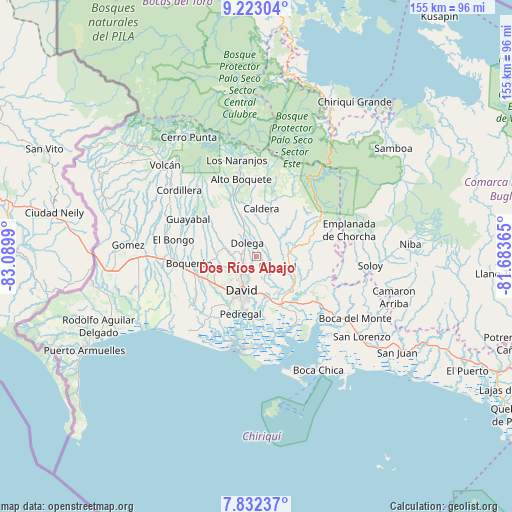
Dos Ríos Abajo GPS coordinates[2]
8° 31' 42.024" North, 82° 23' 12.372" West
| Map corner | latitude | longitude |
|---|---|---|
| Upper-left | 9.22304°, | -83.0899° |
| Center: | 8.52834°, | -82.38677° |
| Lower-right: | 7.83237°, | -81.68365° |
| Map W x H: | 154.6×154.6 km | = 96.1×96.1mi |
| max Lat: | 9.60898° ⇑43.8% North |
| Dos Ríos Abajo: | 8.52834° |
| min Lat: | ⇓56.2% South 7.26534° |
| min Long | Dos Ríos Abajo | max Long |
| -82.91275° | -82.38677° | -77.38965° |
| W 16.4%⇐ | ⇒83.6% E |
Elevation
Elevation of Dos Ríos Abajo is 155 m = 509 ft, and this is 17.1 m = 56 ft below average elevation for this country.
| Max E: |
2103 m = 6900 ft | 30.4% |
| Avg. | 172.1 m = 565 ft | |
| Dos Ríos Abajo | 155 m = 509 ft | |
Min E: |
-1 m = -3 ft | 69.6% |
See also: Panama elevation on elevation.city.
Geographical zone
Dos Ríos Abajo is located in North Torrid zone (between Equator and Tropic of Cancer). Distance of Equator is 948.3 km =589.2 mi to South.| Distance of | km | miles | from Dos Ríos Abajo |
|---|---|---|---|
| North Pole | 9058.8 | 5628.9 | to North |
| Arctic Circle | 6452.9 | 4009.6 | to North |
| Tropic Cancer | 1657.7 | 1030 | to North |
| Equator | 948.3 | 589.2 | to South |


Nearby cities:
15 places around Dos Ríos Abajo: (largest is in red/bold)
• Algarrobos Arriba
4.2 km =2.6 mi,  250°
250°
• Angostura de Cochea Arriba
1.5 km =0.9 mi,  55°
55°
• Bijagual
6 km =3.7 mi,  104°
104°
• Caimito
3.8 km =2.4 mi,  292°
292°
• Cochea Abajo
4 km =2.5 mi,  129°
129°
• Dolega District
5.2 km =3.2 mi,  324°
324°
• Dos Ríos Arriba
3 km =1.9 mi,  331°
331°
• El Flor
7.3 km =4.5 mi,  307°
307°
• Guayabal
8.1 km =5 mi,  156°
156°
• Los Algarrobos
5.5 km =3.4 mi,  228°
228°
• Los Anastacios
4 km =2.5 mi,  273°
273°
• Portachuelo
7.1 km =4.4 mi,  210°
210°
• Pueblo Nuevo
7.3 km =4.5 mi, 327°
• Quinteño
6.4 km =4 mi,  186°
186°
• Rincón Largo
2.3 km =1.4 mi, 248°
Sources, notices
• [Note1] Compared only with cities in Panama existing in our database
• [Src1] Map data: © OpenStreetMap contributors (CC-BY-SA)
• [Src2] Other city data from geonames.org with taken over terms of usage.
• [Src3] Geographical zone / Annual Mean Temperature by Robert A. Rohde @ Wikipedia
