Angostura de Cochea Arriba geodata
Angostura de Cochea Arriba (Chiriquí) is a populated place; located in Panama in America/Panama (GMT-5) time zone. With population of 615 people, there are 403 cities with bigger population in this country. Compared to other cities in Panama, 57.3% of cities are located further ↓South; 83.4% of cities are located further →East and 70.9% of cities have lower elevation than Angostura de Cochea Arriba. Note1
Current local time in Angostura de Cochea Arriba:
06:53 PM, ThursdayDifference from your time zone: hours


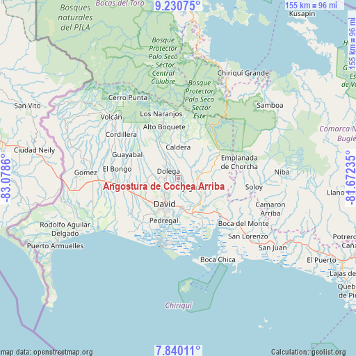
Angostura de Cochea Arriba GPS coordinates[2]
8° 32' 9.816" North, 82° 22' 31.692" West
| Map corner | latitude | longitude |
|---|---|---|
| Upper-left | 9.23075°, | -83.0786° |
| Center: | 8.53606°, | -82.37547° |
| Lower-right: | 7.84011°, | -81.67235° |
| Map W x H: | 154.6×154.6 km | = 96.1×96.1mi |
| max Lat: | 9.60898° ⇑42.7% North |
| Angostura de Cochea Arriba: | 8.53606° |
| min Lat: | ⇓57.3% South 7.26534° |
| min Long | Angostura de Co | max Long |
| -82.91275° | -82.37547° | -77.38965° |
| W 16.6%⇐ | ⇒83.4% E |
Elevation
Elevation of Angostura de Cochea Arriba is 162 m = 531 ft, and this is 10.1 m = 33 ft below average elevation for this country.
| Max E: |
2103 m = 6900 ft | 29.1% |
| Avg. | 172.1 m = 565 ft | |
| Angostura de Cochea Arriba | 162 m = 531 ft | |
Min E: |
-1 m = -3 ft | 70.9% |
See also: Panama elevation on elevation.city.
Geographical zone
Angostura de Cochea Arriba is located in North Torrid zone (between Equator and Tropic of Cancer). Distance of Equator is 949.1 km =589.7 mi to South.| Distance of | km | miles | from Angostura de Cochea Arriba |
|---|---|---|---|
| North Pole | 9057.9 | 5628.3 | to North |
| Arctic Circle | 6452.1 | 4009.1 | to North |
| Tropic Cancer | 1656.8 | 1029.5 | to North |
| Equator | 949.1 | 589.7 | to South |


Nearby cities:
15 places around Angostura de Cochea Arriba: (largest is in red/bold)
• Algarrobos Arriba
5.7 km =3.5 mi,  246°
246°
• Bijagual
5.2 km =3.2 mi,  117°
117°
• Caimito
4.8 km =3 mi,  277°
277°
• Cochea Abajo
3.9 km =2.4 mi,  151°
151°
• Dolega District
5.4 km =3.4 mi,  308°
308°
• Dos Ríos Abajo
1.5 km =0.9 mi,  235°
235°
• Dos Ríos Arriba
3.2 km =2 mi,  303°
303°
• El Flor
7.9 km =4.9 mi, 296°
• Gualaca
8.4 km =5.2 mi,  94°
94°
• Guayabal
8.5 km =5.3 mi,  166°
166°
• Los Algarrobos
7 km =4.3 mi,  230°
230°
• Los Anastacios
5.3 km =3.3 mi,  262°
262°
• Pueblo Nuevo
7.5 km =4.7 mi,  315°
315°
• Quinteño
7.5 km =4.7 mi,  195°
195°
• Rincón Largo
3.8 km =2.4 mi, 243°
Sources, notices
• [Note1] Compared only with cities in Panama existing in our database
• [Src1] Map data: © OpenStreetMap contributors (CC-BY-SA)
• [Src2] Other city data from geonames.org with taken over terms of usage.
• [Src3] Geographical zone / Annual Mean Temperature by Robert A. Rohde @ Wikipedia
