Cochea Abajo geodata
Cochea Abajo (Chiriquí) is a seat of a third-order administrative division; located in Panama in America/Panama (GMT-5) time zone. With population of 435 people, there are 506 cities with bigger population in this country. Compared to other cities in Panama, 53.4% of cities are located further ↓South; 83% of cities are located further →East and 65.6% of cities have lower elevation than Cochea Abajo. Note1


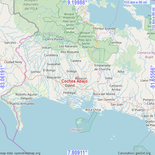
Cochea Abajo GPS coordinates[2]
8° 30' 18.432" North, 82° 21' 31.608" West
| Map corner | latitude | longitude |
|---|---|---|
| Upper-left | 9.19986°, | -83.06191° |
| Center: | 8.50512°, | -82.35878° |
| Lower-right: | 7.80911°, | -81.65566° |
| Map W x H: | 154.6×154.6 km | = 96.1×96.1mi |
| max Lat: | 9.60898° ⇑46.6% North |
| Cochea Abajo: | 8.50512° |
| min Lat: | ⇓53.4% South 7.26534° |
| min Long | Cochea Abajo | max Long |
| -82.91275° | -82.35878° | -77.38965° |
| W 17%⇐ | ⇒83% E |
Elevation
Elevation of Cochea Abajo is 127 m = 417 ft, and this is 45.1 m = 148 ft below average elevation for this country.
| Max E: |
2103 m = 6900 ft | 34.4% |
| Avg. | 172.1 m = 565 ft | |
| Cochea Abajo | 127 m = 417 ft | |
Min E: |
-1 m = -3 ft | 65.6% |
See also: Panama elevation on elevation.city.
Geographical zone
Cochea Abajo is located in North Torrid zone (between Equator and Tropic of Cancer). Distance of Equator is 945.7 km =587.6 mi to South.| Distance of | km | miles | from Cochea Abajo |
|---|---|---|---|
| North Pole | 9061.4 | 5630.5 | to North |
| Arctic Circle | 6455.5 | 4011.3 | to North |
| Tropic Cancer | 1660.2 | 1031.6 | to North |
| Equator | 945.7 | 587.6 | to South |


Nearby cities:
15 places around Cochea Abajo: (largest is in red/bold)
• Algarrobos Arriba
7.1 km =4.4 mi,  279°
279°
• Angostura de Cochea Arriba
3.9 km =2.4 mi,  331°
331°
• Bijagual
3 km =1.9 mi,  68°
68°
• Caimito
7.8 km =4.8 mi,  301°
301°
• Dos Ríos Abajo
4 km =2.5 mi,  309°
309°
• Dos Ríos Arriba
6.9 km =4.3 mi,  318°
318°
• Gualaca
7.1 km =4.4 mi, 66°
• Guayabal
4.8 km =3 mi,  178°
178°
• Las Lomas
9 km =5.6 mi,  200°
200°
• Los Algarrobos
7.3 km =4.5 mi,  261°
261°
• Los Anastacios
7.6 km =4.7 mi,  291°
291°
• Mata del Nance
7.6 km =4.7 mi,  217°
217°
• Portachuelo
7.6 km =4.7 mi,  241°
241°
• Quinteño
5.4 km =3.4 mi,  225°
225°
• Rincón Largo
5.5 km =3.4 mi, 288°
Sources, notices
• [Note1] Compared only with cities in Panama existing in our database
• [Src1] Map data: © OpenStreetMap contributors (CC-BY-SA)
• [Src2] Other city data from geonames.org with taken over terms of usage.
• [Src3] Geographical zone / Annual Mean Temperature by Robert A. Rohde @ Wikipedia
