Rincón Largo geodata
Rincón Largo (Chiriquí) is a populated place; located in Panama in America/Panama (GMT-5) time zone. With population of 979 people, there are 263 cities with bigger population in this country. Compared to other cities in Panama, 55.3% of cities are located further ↓South; 84.4% of cities are located further →East and 71.3% of cities have lower elevation than Rincón Largo. Note1


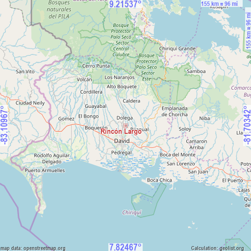
Rincón Largo GPS coordinates[2]
8° 31' 14.34" North, 82° 24' 23.544" West
| Map corner | latitude | longitude |
|---|---|---|
| Upper-left | 9.21537°, | -83.10967° |
| Center: | 8.52065°, | -82.40654° |
| Lower-right: | 7.82467°, | -81.70342° |
| Map W x H: | 154.6×154.6 km | = 96.1×96.1mi |
| max Lat: | 9.60898° ⇑44.7% North |
| Rincón Largo: | 8.52065° |
| min Lat: | ⇓55.3% South 7.26534° |
| min Long | Rincón Largo | max Long |
| -82.91275° | -82.40654° | -77.38965° |
| W 15.6%⇐ | ⇒84.4% E |
Elevation
Elevation of Rincón Largo is 164 m = 538 ft, and this is 8.1 m = 27 ft below average elevation for this country.
| Max E: |
2103 m = 6900 ft | 28.7% |
| Avg. | 172.1 m = 565 ft | |
| Rincón Largo | 164 m = 538 ft | |
Min E: |
-1 m = -3 ft | 71.3% |
See also: Panama elevation on elevation.city.
Geographical zone
Rincón Largo is located in North Torrid zone (between Equator and Tropic of Cancer). Distance of Equator is 947.4 km =588.7 mi to South.| Distance of | km | miles | from Rincón Largo |
|---|---|---|---|
| North Pole | 9059.7 | 5629.4 | to North |
| Arctic Circle | 6453.8 | 4010.2 | to North |
| Tropic Cancer | 1658.5 | 1030.5 | to North |
| Equator | 947.4 | 588.7 | to South |


Nearby cities:
15 places around Rincón Largo: (largest is in red/bold)
• Algarrobos Arriba
1.9 km =1.2 mi,  252°
252°
• Angostura de Cochea Arriba
3.8 km =2.4 mi,  63°
63°
• Caimito
2.7 km =1.7 mi,  329°
329°
• Cochea Abajo
5.5 km =3.4 mi,  108°
108°
• Dolega District
5.2 km =3.2 mi,  350°
350°
• Dos Ríos Abajo
2.3 km =1.4 mi,  68°
68°
• Dos Ríos Arriba
3.5 km =2.2 mi,  12°
12°
• El Flor
6.4 km =4 mi, 325°
• Los Algarrobos
3.4 km =2.1 mi,  215°
215°
• Los Anastacios
2.1 km =1.3 mi,  300°
300°
• Portachuelo
5.5 km =3.4 mi,  194°
194°
• Pueblo Nuevo
7.3 km =4.5 mi, 345°
• Quinteño
5.7 km =3.5 mi,  165°
165°
• San Carlitos
6.3 km =3.9 mi,  230°
230°
• Tinajas
6.8 km =4.2 mi, 301°
Sources, notices
• [Note1] Compared only with cities in Panama existing in our database
• [Src1] Map data: © OpenStreetMap contributors (CC-BY-SA)
• [Src2] Other city data from geonames.org with taken over terms of usage.
• [Src3] Geographical zone / Annual Mean Temperature by Robert A. Rohde @ Wikipedia
