Isla Bastimentos geodata
Isla Bastimentos (Bocas del Toro) is a populated place; located in Panama in America/Panama (GMT-5) time zone. With population of 1,500 people, there are 156 cities with bigger population in this country. Compared to other cities in Panama, 94.8% of cities are located further ↓South; 80.1% of cities are located further →East and 73.6% of cities have higher elevation than Isla Bastimentos. Note1


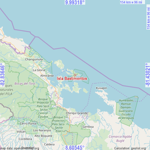
Isla Bastimentos GPS coordinates[2]
9° 18' 0" North, 82° 7' 59.988" West
| Map corner | latitude | longitude |
|---|---|---|
| Upper-left | 9.99318°, | -82.83646° |
| Center: | 9.3°, | -82.13333° |
| Lower-right: | 8.60545°, | -81.43021° |
| Map W x H: | 154.3×154.3 km | = 95.9×95.9mi |
| max Lat: | 9.60898° ⇑5.2% North |
| Isla Bastimentos: | 9.3° |
| min Lat: | ⇓94.8% South 7.26534° |
| min Long | Isla Bastimento | max Long |
| -82.91275° | -82.13333° | -77.38965° |
| W 19.9%⇐ | ⇒80.1% E |
Elevation
Elevation of Isla Bastimentos is 32 m = 105 ft, and this is 140.1 m = 460 ft below average elevation for this country.
| Max E: |
2103 m = 6900 ft | 73.6% |
| Avg. | 172.1 m = 565 ft | |
| Isla Bastimentos | 32 m = 105 ft | |
Min E: |
-1 m = -3 ft | 26.4% |
See also: Panama elevation on elevation.city.
Geographical zone
Isla Bastimentos is located in North Torrid zone (between Equator and Tropic of Cancer). Distance of Equator is 1034.1 km =642.6 mi to South.| Distance of | km | miles | from Isla Bastimentos |
|---|---|---|---|
| North Pole | 8973 | 5575.6 | to North |
| Arctic Circle | 6367.1 | 3956.3 | to North |
| Tropic Cancer | 1571.9 | 976.7 | to North |
| Equator | 1034.1 | 642.6 | to South |


Nearby cities:
15 places around Isla Bastimentos: (largest is in red/bold)
• Almirante
29.5 km =18.3 mi,  270°
270°
• Bahía Azul
31.6 km =19.6 mi,  123°
123°
• Bastimentos
9.8 km =6.1 mi,  302°
302°
• Bocas del Toro
12.7 km =7.9 mi,  290°
290°
• Cauchero
21.8 km =13.5 mi,  221°
221°
• Cayo de Agua
18.7 km =11.6 mi,  152°
152°
• Isla Tigre
15.1 km =9.4 mi,  157°
157°
• Kusapín
30.4 km =18.9 mi, 116°
• Miramar
35.9 km =22.3 mi,  199°
199°
• Nuevo Paraiso
30.6 km =19 mi, 265°
• Punta Laurel
17.7 km =11 mi,  177°
177°
• Punta Róbalo
32 km =19.9 mi, 203°
• Quebrada Pastor
26.9 km =16.7 mi,  248°
248°
• San Cristóbal
14.9 km =9.3 mi,  261°
261°
• Valle del Risco
33.2 km =20.6 mi, 256°
Sources, notices
• [Note1] Compared only with cities in Panama existing in our database
• [Src1] Map data: © OpenStreetMap contributors (CC-BY-SA)
• [Src2] Other city data from geonames.org with taken over terms of usage.
• [Src3] Geographical zone / Annual Mean Temperature by Robert A. Rohde @ Wikipedia
