Arenosa geodata
Arenosa (Panamá Oeste) is a seat of a third-order administrative division; located in Panama in America/Panama (GMT-5) time zone. With population of 319 people, there are 550 cities with bigger population in this country. Compared to other cities in Panama, 84.9% of cities are located further ↓South; 73.9% of cities are located further ←West and 77% of cities have higher elevation than Arenosa. Note1


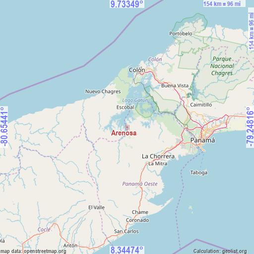
Arenosa GPS coordinates[2]
9° 2' 23.208" North, 79° 57' 4.608" West
| Map corner | latitude | longitude |
|---|---|---|
| Upper-left | 9.73349°, | -80.65441° |
| Center: | 9.03978°, | -79.95128° |
| Lower-right: | 8.34474°, | -79.24816° |
| Map W x H: | 154.4×154.4 km | = 95.9×95.9mi |
| max Lat: | 9.60898° ⇑15.1% North |
| Arenosa: | 9.03978° |
| min Lat: | ⇓84.9% South 7.26534° |
| min Long | Arenosa | max Long |
| -82.91275° | -79.95128° | -77.38965° |
| W 73.9%⇐ | ⇒26.1% E |
Elevation
Elevation of Arenosa is 28 m = 92 ft, and this is 144.1 m = 473 ft below average elevation for this country.
| Max E: |
2103 m = 6900 ft | 77% |
| Avg. | 172.1 m = 565 ft | |
| Arenosa | 28 m = 92 ft | |
Min E: |
-1 m = -3 ft | 23% |
See also: Panama elevation on elevation.city.
Geographical zone
Arenosa is located in North Torrid zone (between Equator and Tropic of Cancer). Distance of Equator is 1005.1 km =624.5 mi to South.| Distance of | km | miles | from Arenosa |
|---|---|---|---|
| North Pole | 9001.9 | 5593.5 | to North |
| Arctic Circle | 6396 | 3974.3 | to North |
| Tropic Cancer | 1600.8 | 994.7 | to North |
| Equator | 1005.1 | 624.5 | to South |


Nearby cities:
15 places around Arenosa: (largest is in red/bold)
• Achiote
20.2 km =12.6 mi,  340°
340°
• Arosemena
7.8 km =4.8 mi,  192°
192°
• Cerro Cama
5 km =3.1 mi,  105°
105°
• Cirí de Los Sotos
17.2 km =10.7 mi,  244°
244°
• Cuipo
11.2 km =7 mi,  286°
286°
• El Guabo
15.1 km =9.4 mi, 286°
• Escobal
11.6 km =7.2 mi,  352°
352°
• La Colorada
7.5 km =4.7 mi,  151°
151°
• La Laguna
12 km =7.5 mi,  87°
87°
• Lagarterita
6 km =3.7 mi,  42°
42°
• Mendoza
11.4 km =7.1 mi,  104°
104°
• Nueva Arenosa
19.5 km =12.1 mi, 194°
• Santa Clara
21.7 km =13.5 mi, 93°
• Santa Rita
21.8 km =13.5 mi,  158°
158°
• Zangüengas
12.9 km =8 mi,  136°
136°
Sources, notices
• [Note1] Compared only with cities in Panama existing in our database
• [Src1] Map data: © OpenStreetMap contributors (CC-BY-SA)
• [Src2] Other city data from geonames.org with taken over terms of usage.
• [Src3] Geographical zone / Annual Mean Temperature by Robert A. Rohde @ Wikipedia
