San Miguel Centro geodata
San Miguel Centro (Coclé) is a populated place; located in Panama in America/Panama (GMT-5) time zone. With population of 926 people, there are 275 cities with bigger population in this country. Compared to other cities in Panama, 71.5% of cities are located further ↓South; 68.4% of cities are located further ←West and 76.7% of cities have lower elevation than San Miguel Centro. Note1


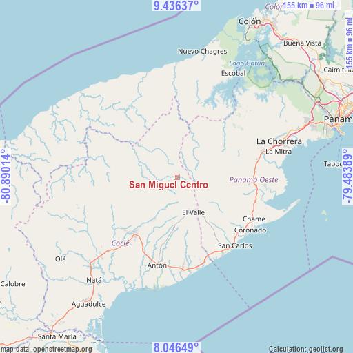
San Miguel Centro GPS coordinates[2]
8° 44' 31.488" North, 80° 11' 13.236" West
| Map corner | latitude | longitude |
|---|---|---|
| Upper-left | 9.43637°, | -80.89014° |
| Center: | 8.74208°, | -80.18701° |
| Lower-right: | 8.04649°, | -79.48389° |
| Map W x H: | 154.5×154.5 km | = 96×96mi |
| max Lat: | 9.60898° ⇑28.5% North |
| San Miguel Centro: | 8.74208° |
| min Lat: | ⇓71.5% South 7.26534° |
| min Long | San Miguel Cent | max Long |
| -82.91275° | -80.18701° | -77.38965° |
| W 68.4%⇐ | ⇒31.6% E |
Elevation
Elevation of San Miguel Centro is 212 m = 696 ft, and this is 39.9 m = 131 ft above average elevation for this country.
| Max E: |
2103 m = 6900 ft | 23.3% |
| San Miguel Centro | 212 m 696 ft | |
| Avg. | 172.1 m = 565 ft | |
Min E: |
-1 m = -3 ft | 76.7% |
See also: Panama elevation on elevation.city.
Geographical zone
San Miguel Centro is located in North Torrid zone (between Equator and Tropic of Cancer). Distance of Equator is 972 km =604 mi to South.| Distance of | km | miles | from San Miguel Centro |
|---|---|---|---|
| North Pole | 9035 | 5614.1 | to North |
| Arctic Circle | 6429.1 | 3994.9 | to North |
| Tropic Cancer | 1633.9 | 1015.3 | to North |
| Equator | 972 | 604 | to South |


Nearby cities:
15 places around San Miguel Centro: (largest is in red/bold)
• Alto de La Estancia
17.1 km =10.6 mi,  179°
179°
• Caimito
14.5 km =9 mi,  203°
203°
• Chiguirí Arriba
7.8 km =4.8 mi, 182°
• Ciricito Abajo
13.6 km =8.5 mi,  62°
62°
• Las Marias
16.6 km =10.3 mi,  347°
347°
• Mata Ahogado
17.2 km =10.7 mi,  143°
143°
• Miraflores
16.3 km =10.1 mi,  217°
217°
• San Pedro
4.5 km =2.8 mi,  240°
240°
• Santa Rosa Número Uno
16.7 km =10.4 mi,  35°
35°
• Sofre
14.5 km =9 mi,  193°
193°
• Tambo
14.7 km =9.1 mi,  232°
232°
• Tavidal Arriba
6.8 km =4.2 mi,  169°
169°
• Toabré
17.8 km =11.1 mi, 235°
• Turega
14.5 km =9 mi, 183°
• Vaquilla
5.3 km =3.3 mi, 190°
Sources, notices
• [Note1] Compared only with cities in Panama existing in our database
• [Src1] Map data: © OpenStreetMap contributors (CC-BY-SA)
• [Src2] Other city data from geonames.org with taken over terms of usage.
• [Src3] Geographical zone / Annual Mean Temperature by Robert A. Rohde @ Wikipedia
