Mata Ahogado geodata
Mata Ahogado (Panamá Oeste) is a populated place; located in Panama in America/Panama (GMT-5) time zone. With population of 614 people, there are 404 cities with bigger population in this country. Compared to other cities in Panama, 64.7% of cities are located further ↓South; 70.7% of cities are located further ←West and 95.5% of cities have lower elevation than Mata Ahogado. Note1


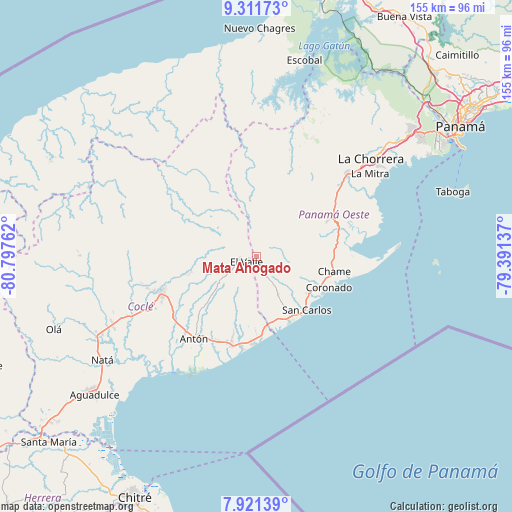
Mata Ahogado GPS coordinates[2]
8° 37' 1.92" North, 80° 5' 40.164" West
| Map corner | latitude | longitude |
|---|---|---|
| Upper-left | 9.31173°, | -80.79762° |
| Center: | 8.6172°, | -80.09449° |
| Lower-right: | 7.92139°, | -79.39137° |
| Map W x H: | 154.6×154.6 km | = 96.1×96.1mi |
| max Lat: | 9.60898° ⇑35.3% North |
| Mata Ahogado: | 8.6172° |
| min Lat: | ⇓64.7% South 7.26534° |
| min Long | Mata Ahogado | max Long |
| -82.91275° | -80.09449° | -77.38965° |
| W 70.7%⇐ | ⇒29.3% E |
Elevation
Elevation of Mata Ahogado is 761 m = 2497 ft, and this is 588.9 m = 1932 ft above average elevation for this country.
| Max E: |
2103 m = 6900 ft | 4.5% |
| Mata Ahogado | 761 m 2497 ft | |
| Avg. | 172.1 m = 565 ft | |
Min E: |
-1 m = -3 ft | 95.5% |
See also: Panama elevation on elevation.city.
Geographical zone
Mata Ahogado is located in North Torrid zone (between Equator and Tropic of Cancer). Distance of Equator is 958.1 km =595.3 mi to South.| Distance of | km | miles | from Mata Ahogado |
|---|---|---|---|
| North Pole | 9048.9 | 5622.7 | to North |
| Arctic Circle | 6443 | 4003.5 | to North |
| Tropic Cancer | 1647.8 | 1023.9 | to North |
| Equator | 958.1 | 595.3 | to South |


Nearby cities:
15 places around Mata Ahogado: (largest is in red/bold)
• Alto de La Estancia
10.4 km =6.5 mi,  251°
251°
• Caballero
14 km =8.7 mi,  234°
234°
• Cabuya
11.2 km =7 mi, 225°
• Chiguirí Arriba
12.1 km =7.5 mi,  300°
300°
• Entradero
13.5 km =8.4 mi, 246°
• Guayabito
11.7 km =7.3 mi,  130°
130°
• La Laguna
5.4 km =3.4 mi,  105°
105°
• Las Colinas
7.6 km =4.7 mi,  170°
170°
• Los Llanitos
2.2 km =1.4 mi,  181°
181°
• Membrillo
13.6 km =8.5 mi, 253°
• Sofre
13.4 km =8.3 mi,  269°
269°
• Sorá
9.6 km =6 mi,  80°
80°
• Tavidal Arriba
11.5 km =7.1 mi,  309°
309°
• Turega
11 km =6.8 mi, 267°
• Vaquilla
14.1 km =8.8 mi, 307°
Sources, notices
• [Note1] Compared only with cities in Panama existing in our database
• [Src1] Map data: © OpenStreetMap contributors (CC-BY-SA)
• [Src2] Other city data from geonames.org with taken over terms of usage.
• [Src3] Geographical zone / Annual Mean Temperature by Robert A. Rohde @ Wikipedia
