Alto de Jesús geodata
Alto de Jesús (Veraguas) is a seat of a third-order administrative division; located in Panama in America/Panama (GMT-5) time zone. With population of 361 people, there are 534 cities with bigger population in this country. Compared to other cities in Panama, 68.6% of cities are located further ↑North; 69.5% of cities are located further →East and 84.9% of cities have lower elevation than Alto de Jesús. Note1


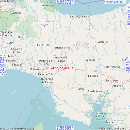
Alto de Jesús GPS coordinates[2]
8° 15' 41.472" North, 81° 29' 2.832" West
| Map corner | latitude | longitude |
|---|---|---|
| Upper-left | 8.95672°, | -82.18725° |
| Center: | 8.26152°, | -81.48412° |
| Lower-right: | 7.56509°, | -80.781° |
| Map W x H: | 154.7×154.7 km | = 96.1×96.1mi |
| max Lat: | 9.60898° ⇑68.6% North |
| Alto de Jesús: | 8.26152° |
| min Lat: | ⇓31.4% South 7.26534° |
| min Long | Alto de Jesús | max Long |
| -82.91275° | -81.48412° | -77.38965° |
| W 30.5%⇐ | ⇒69.5% E |
Elevation
Elevation of Alto de Jesús is 338 m = 1109 ft, and this is 165.9 m = 544 ft above average elevation for this country.
| Max E: |
2103 m = 6900 ft | 15.1% |
| Alto de Jesús | 338 m 1109 ft | |
| Avg. | 172.1 m = 565 ft | |
Min E: |
-1 m = -3 ft | 84.9% |
See also: Panama elevation on elevation.city.
Geographical zone
Alto de Jesús is located in North Torrid zone (between Equator and Tropic of Cancer). Distance of Equator is 918.6 km =570.8 mi to South.| Distance of | km | miles | from Alto de Jesús |
|---|---|---|---|
| North Pole | 9088.5 | 5647.3 | to North |
| Arctic Circle | 6482.6 | 4028.1 | to North |
| Tropic Cancer | 1687.3 | 1048.4 | to North |
| Equator | 918.6 | 570.8 | to South |


Nearby cities:
15 places around Alto de Jesús: (largest is in red/bold)
• Bajo Solis
10.8 km =6.7 mi,  332°
332°
• Bella Vista
16.3 km =10.1 mi,  247°
247°
• Buenos Aires
16.9 km =10.5 mi,  359°
359°
• Cerro Iglesias
10.9 km =6.8 mi,  305°
305°
• Cerro Pelado
12.6 km =7.8 mi,  208°
208°
• Cerro Venado
10.6 km =6.6 mi, 249°
• Cerro Viejo
10.2 km =6.3 mi,  264°
264°
• Cerro de Plata
13.1 km =8.1 mi,  77°
77°
• El Piro
7.5 km =4.7 mi,  219°
219°
• El Prado
3.5 km =2.2 mi, 219°
• El Rincón
10.3 km =6.4 mi,  146°
146°
• Las Palmas
14.3 km =8.9 mi,  167°
167°
• San José
15.1 km =9.4 mi,  35°
35°
• Sitio Prado
16.3 km =10.1 mi,  319°
319°
• Viguí
8.8 km =5.5 mi,  349°
349°
Sources, notices
• [Note1] Compared only with cities in Panama existing in our database
• [Src1] Map data: © OpenStreetMap contributors (CC-BY-SA)
• [Src2] Other city data from geonames.org with taken over terms of usage.
• [Src3] Geographical zone / Annual Mean Temperature by Robert A. Rohde @ Wikipedia
