San José geodata
San José (Veraguas) is a seat of a third-order administrative division; located in Panama in America/Panama (GMT-5) time zone. In our database, there are 694 cities with bigger population. Compared to other cities in Panama, 60.2% of cities are located further ↑North; 68.4% of cities are located further →East and 78% of cities have lower elevation than San José. Note1


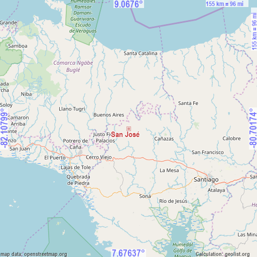
San José GPS coordinates[2]
8° 22' 21.396" North, 81° 24' 17.496" West
| Map corner | latitude | longitude |
|---|---|---|
| Upper-left | 9.0676°, | -82.10799° |
| Center: | 8.37261°, | -81.40486° |
| Lower-right: | 7.67637°, | -80.70174° |
| Map W x H: | 154.7×154.7 km | = 96.1×96.1mi |
| max Lat: | 9.60898° ⇑60.2% North |
| San José: | 8.37261° |
| min Lat: | ⇓39.8% South 7.26534° |
| min Long | San José | max Long |
| -82.91275° | -81.40486° | -77.38965° |
| W 31.6%⇐ | ⇒68.4% E |
Elevation
Elevation of San José is 231 m = 758 ft, and this is 58.9 m = 193 ft above average elevation for this country.
| Max E: |
2103 m = 6900 ft | 22% |
| San José | 231 m 758 ft | |
| Avg. | 172.1 m = 565 ft | |
Min E: |
-1 m = -3 ft | 78% |
See also: Panama elevation on elevation.city.
Geographical zone
San José is located in North Torrid zone (between Equator and Tropic of Cancer). Distance of Equator is 930.9 km =578.4 mi to South.| Distance of | km | miles | from San José |
|---|---|---|---|
| North Pole | 9076.1 | 5639.6 | to North |
| Arctic Circle | 6470.2 | 4020.4 | to North |
| Tropic Cancer | 1675 | 1040.8 | to North |
| Equator | 930.9 | 578.4 | to South |


Nearby cities:
15 places around San José: (largest is in red/bold)
• Agua de Salud
16.1 km =10 mi,  336°
336°
• Alto de Jesús
15.1 km =9.4 mi,  215°
215°
• Bajo Solis
14 km =8.7 mi,  258°
258°
• Buenos Aires
9.9 km =6.2 mi,  297°
297°
• Cerro Iglesias
18.5 km =11.5 mi,  251°
251°
• Cerro Plata
19.4 km =12.1 mi,  306°
306°
• Cerro de Plata
10.2 km =6.3 mi,  156°
156°
• El Bale
5.1 km =3.2 mi,  109°
109°
• El Picador
16.4 km =10.2 mi,  87°
87°
• El Prado
18.6 km =11.6 mi, 216°
• El Rincón
21.2 km =13.2 mi,  188°
188°
• Guayabito
20.4 km =12.7 mi, 335°
• Güibale
16.2 km =10.1 mi,  16°
16°
• Sitio Prado
19.4 km =12.1 mi,  269°
269°
• Viguí
10.9 km =6.8 mi, 250°
Sources, notices
• [Note1] Compared only with cities in Panama existing in our database
• [Src1] Map data: © OpenStreetMap contributors (CC-BY-SA)
• [Src2] Other city data from geonames.org with taken over terms of usage.
• [Src3] Geographical zone / Annual Mean Temperature by Robert A. Rohde @ Wikipedia
