Cerro Iglesias geodata
Cerro Iglesias (Chiriquí) is a seat of a third-order administrative division; located in Panama in America/Panama (GMT-5) time zone. In our database, there are 694 cities with bigger population. Compared to other cities in Panama, 65.2% of cities are located further ↑North; 70.7% of cities are located further →East and 92.1% of cities have lower elevation than Cerro Iglesias. Note1


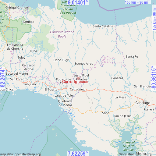
Cerro Iglesias GPS coordinates[2]
8° 19' 8.112" North, 81° 33' 51.372" West
| Map corner | latitude | longitude |
|---|---|---|
| Upper-left | 9.01401°, | -82.2674° |
| Center: | 8.31892°, | -81.56427° |
| Lower-right: | 7.62259°, | -80.86115° |
| Map W x H: | 154.7×154.7 km | = 96.1×96.1mi |
| max Lat: | 9.60898° ⇑65.2% North |
| Cerro Iglesias: | 8.31892° |
| min Lat: | ⇓34.8% South 7.26534° |
| min Long | Cerro Iglesias | max Long |
| -82.91275° | -81.56427° | -77.38965° |
| W 29.3%⇐ | ⇒70.7% E |
Elevation
Elevation of Cerro Iglesias is 497 m = 1631 ft, and this is 324.9 m = 1066 ft above average elevation for this country.
| Max E: |
2103 m = 6900 ft | 7.9% |
| Cerro Iglesias | 497 m 1631 ft | |
| Avg. | 172.1 m = 565 ft | |
Min E: |
-1 m = -3 ft | 92.1% |
See also: Panama elevation on elevation.city.
Geographical zone
Cerro Iglesias is located in North Torrid zone (between Equator and Tropic of Cancer). Distance of Equator is 925 km =574.8 mi to South.| Distance of | km | miles | from Cerro Iglesias |
|---|---|---|---|
| North Pole | 9082.1 | 5643.4 | to North |
| Arctic Circle | 6476.2 | 4024.1 | to North |
| Tropic Cancer | 1680.9 | 1044.5 | to North |
| Equator | 925 | 574.8 | to South |


Nearby cities:
15 places around Cerro Iglesias: (largest is in red/bold)
• Alto Caballero
12.4 km =7.7 mi,  254°
254°
• Alto de Jesús
10.9 km =6.8 mi,  125°
125°
• Bajo Solis
5 km =3.1 mi,  50°
50°
• Cerro Caña
6.3 km =3.9 mi,  305°
305°
• Cerro Venado
10.1 km =6.3 mi,  186°
186°
• Cerro Viejo
7.4 km =4.6 mi, 190°
• Chichica
12 km =7.5 mi,  291°
291°
• Chichica
12.5 km =7.8 mi,  295°
295°
• El Piro
12.8 km =8 mi,  161°
161°
• El Prado
11.2 km =7 mi,  143°
143°
• Llano Limón
13.1 km =8.1 mi,  230°
230°
• Llano Ñopo
12.7 km =7.9 mi,  331°
331°
• Pueblo Viejo
13.2 km =8.2 mi,  235°
235°
• Sitio Prado
6.2 km =3.9 mi,  342°
342°
• Viguí
7.6 km =4.7 mi,  72°
72°
Sources, notices
• [Note1] Compared only with cities in Panama existing in our database
• [Src1] Map data: © OpenStreetMap contributors (CC-BY-SA)
• [Src2] Other city data from geonames.org with taken over terms of usage.
• [Src3] Geographical zone / Annual Mean Temperature by Robert A. Rohde @ Wikipedia
