San Marcos geodata
San Marcos (Cajamarca) is a seat of a third-order administrative division; located in Peru in America/Lima (GMT-5) time zone. In our database, there are 305 cities with bigger population. Compared to other cities in Peru, 76.9% of cities are located further ↓South; 83.3% of cities are located further →East and 62.2% of cities have higher elevation than San Marcos. Note1


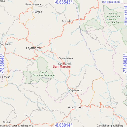
San Marcos GPS coordinates[2]
7° 19' 59.988" South, 78° 10' 59.988" West
| Map corner | latitude | longitude |
|---|---|---|
| Upper-left | -6.63543°, | -78.88646° |
| Center: | -7.33333°, | -78.18333° |
| Lower-right: | -8.03014°, | -77.48021° |
| Map W x H: | 155.1×155.1 km | = 96.4×96.4mi |
| max Lat: | -0.96667° ⇑23.1% North |
| San Marcos: | -7.33333° |
| min Lat: | ⇓76.9% South -18.01465° |
| min Long | San Marcos | max Long |
| -81.30472° | -78.18333° | -69.04167° |
| W 16.7%⇐ | ⇒83.3% E |
Elevation
Elevation of San Marcos is 2294 m = 7526 ft, and this is 24.7 m = 81 ft below average elevation for this country.
| Max E: |
5022 m = 16476 ft | 62.2% |
| Avg. | 2318.7 m = 7607 ft | |
| San Marcos | 2294 m = 7526 ft | |
Min E: |
1 m = 3 ft | 37.8% |
See also: Peru elevation on elevation.city.
Geographical zone
San Marcos is located in South Torrid zone (between Equator and Tropic of Capricorn). Distance of Equator is 815.4 km =506.7 mi to North.| Distance of | km | miles | from San Marcos |
|---|---|---|---|
| Equator | 815.4 | 506.7 | to North |
| Tropic Capricorn | 1790.5 | 1112.6 | to South |
| Antarctic Circle | 6585.8 | 4092.2 | to South |
| South Pole | 9191.7 | 5711.5 | to South |


Nearby cities:
15 places around San Marcos: (largest is in red/bold)
• Cachachi
17 km =10.6 mi,  220°
220°
• Cajabamba
34.8 km =21.6 mi,  154°
154°
• Cajamarca
39.7 km =24.7 mi,  298°
298°
• Cauday
29.9 km =18.6 mi,  158°
158°
• Encañada
33.3 km =20.7 mi,  326°
326°
• La Grama
15.8 km =9.8 mi, 159°
• Llacanora
31.3 km =19.4 mi, 298°
• Lluchubamba
31.4 km =19.5 mi,  131°
131°
• Longotea
41.8 km =26 mi,  44°
44°
• Namora
22.2 km =13.8 mi,  311°
311°
• Oxamarca
35.8 km =22.2 mi,  21°
21°
• San Juan
35.1 km =21.8 mi,  276°
276°
• Sayapullo
43.1 km =26.8 mi,  226°
226°
• Shirac
14.8 km =9.2 mi,  97°
97°
• Ucuncha
39.9 km =24.8 mi,  56°
56°
Sources, notices
• [Note1] Compared only with cities in Peru existing in our database
• [Src1] Map data: © OpenStreetMap contributors (CC-BY-SA)
• [Src2] Other city data from geonames.org with taken over terms of usage.
• [Src3] Geographical zone / Annual Mean Temperature by Robert A. Rohde @ Wikipedia
