Cauday geodata
Cauday (Cajamarca) is a seat of a third-order administrative division; located in Peru in America/Lima (GMT-5) time zone. In our database, there are 305 cities with bigger population. Compared to other cities in Peru, 76% of cities are located further ↓South; 82.6% of cities are located further →East and 55% of cities have higher elevation than Cauday. Note1


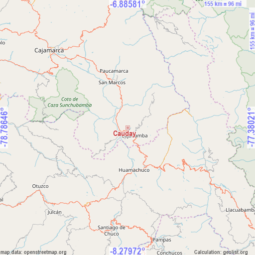
Cauday GPS coordinates[2]
7° 34' 59.988" South, 78° 4' 59.988" West
| Map corner | latitude | longitude |
|---|---|---|
| Upper-left | -6.88581°, | -78.78646° |
| Center: | -7.58333°, | -78.08333° |
| Lower-right: | -8.27972°, | -77.38021° |
| Map W x H: | 155×155 km | = 96.3×96.3mi |
| max Lat: | -0.96667° ⇑24% North |
| Cauday: | -7.58333° |
| min Lat: | ⇓76% South -18.01465° |
| min Long | Cauday | max Long |
| -81.30472° | -78.08333° | -69.04167° |
| W 17.4%⇐ | ⇒82.6% E |
Elevation
Elevation of Cauday is 2682 m = 8799 ft, and this is 363.3 m = 1192 ft above average elevation for this country.
| Max E: |
5022 m = 16476 ft | 55% |
| Cauday | 2682 m 8799 ft | |
| Avg. | 2318.7 m = 7607 ft | |
Min E: |
1 m = 3 ft | 45% |
See also: Peru elevation on elevation.city.
Geographical zone
Cauday is located in South Torrid zone (between Equator and Tropic of Capricorn). Distance of Equator is 843.2 km =523.9 mi to North.| Distance of | km | miles | from Cauday |
|---|---|---|---|
| Equator | 843.2 | 523.9 | to North |
| Tropic Capricorn | 1762.7 | 1095.3 | to South |
| Antarctic Circle | 6558 | 4075 | to South |
| South Pole | 9163.9 | 5694.2 | to South |


Nearby cities:
15 places around Cauday: (largest is in red/bold)
• Cachachi
26.6 km =16.5 mi,  303°
303°
• Cajabamba
5.2 km =3.2 mi,  135°
135°
• Chugay
32.4 km =20.1 mi,  132°
132°
• Curgos
34.4 km =21.4 mi,  153°
153°
• Huamachuco
24.2 km =15 mi,  175°
175°
• Huaranchal
41.9 km =26 mi,  254°
254°
• La Grama
14.1 km =8.8 mi,  336°
336°
• Lluchubamba
14.2 km =8.8 mi,  61°
61°
• Marcabal
14.1 km =8.8 mi,  156°
156°
• Quiruvilca
44.5 km =27.7 mi,  196°
196°
• San Marcos
29.9 km =18.6 mi, 338°
• Sartimbamba
39.6 km =24.6 mi,  108°
108°
• Sayapullo
42.3 km =26.3 mi,  267°
267°
• Shirac
26.2 km =16.3 mi,  8°
8°
• Usquil
45 km =28 mi,  234°
234°
Sources, notices
• [Note1] Compared only with cities in Peru existing in our database
• [Src1] Map data: © OpenStreetMap contributors (CC-BY-SA)
• [Src2] Other city data from geonames.org with taken over terms of usage.
• [Src3] Geographical zone / Annual Mean Temperature by Robert A. Rohde @ Wikipedia
