Saña geodata
Saña (Lambayeque) is a populated place; located in Peru in America/Lima (GMT-5) time zone. With population of 39,200 people, there are 46 cities with bigger population in this country. Compared to other cities in Peru, 80.4% of cities are located further ↓South; 93.7% of cities are located further →East and 91.8% of cities have higher elevation than Saña. Note1


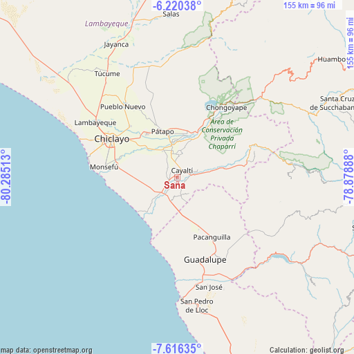
Saña GPS coordinates[2]
6° 55' 7.968" South, 79° 34' 55.2" West
| Map corner | latitude | longitude |
|---|---|---|
| Upper-left | -6.22038°, | -80.28513° |
| Center: | -6.91888°, | -79.582° |
| Lower-right: | -7.61635°, | -78.87888° |
| Map W x H: | 155.2×155.2 km | = 96.4×96.4mi |
| max Lat: | -0.96667° ⇑19.6% North |
| Saña: | -6.91888° |
| min Lat: | ⇓80.4% South -18.01465° |
| min Long | Saña | max Long |
| -81.30472° | -79.582° | -69.04167° |
| W 6.3%⇐ | ⇒93.7% E |
Elevation
Elevation of Saña is 65 m = 213 ft, and this is 2253.7 m = 7394 ft below average elevation for this country.
| Max E: |
5022 m = 16476 ft | 91.8% |
| Avg. | 2318.7 m = 7607 ft | |
| Saña | 65 m = 213 ft | |
Min E: |
1 m = 3 ft | 8.2% |
See also: Peru elevation on elevation.city.
Geographical zone
Saña is located in South Torrid zone (between Equator and Tropic of Capricorn). Distance of Equator is 769.3 km =478 mi to North.| Distance of | km | miles | from Saña |
|---|---|---|---|
| Equator | 769.3 | 478 | to North |
| Tropic Capricorn | 1836.6 | 1141.2 | to South |
| Antarctic Circle | 6631.9 | 4120.9 | to South |
| South Pole | 9237.8 | 5740.1 | to South |


Nearby cities:
15 places around Saña: (largest is in red/bold)
• Chiclayo
33 km =20.5 mi,  299°
299°
• Eten
31.2 km =19.4 mi,  272°
272°
• Manuel Antonio Mesones Muro
35.1 km =21.8 mi,  330°
330°
• Mocupe
8.9 km =5.5 mi,  207°
207°
• Monsefú
32 km =19.9 mi,  278°
278°
• Nueva Arica
26.9 km =16.7 mi,  79°
79°
• Oyotún
32.1 km =19.9 mi, 75°
• Pacanga
29 km =18 mi,  161°
161°
• Picsi
30.5 km =19 mi,  317°
317°
• Pomalca
27.3 km =17 mi,  307°
307°
• Pueblo Nuevo
30.8 km =19.1 mi,  166°
166°
• Reque
26.7 km =16.6 mi, 282°
• San José
33.7 km =20.9 mi, 306°
• Santa Rosa
32.5 km =20.2 mi, 303°
• Santa Rosa
37.5 km =23.3 mi, 276°
Sources, notices
• [Note1] Compared only with cities in Peru existing in our database
• [Src1] Map data: © OpenStreetMap contributors (CC-BY-SA)
• [Src2] Other city data from geonames.org with taken over terms of usage.
• [Src3] Geographical zone / Annual Mean Temperature by Robert A. Rohde @ Wikipedia
