Pueblo Nuevo geodata
Pueblo Nuevo (La Libertad) is a seat of a third-order administrative division; located in Peru in America/Lima (GMT-5) time zone. With population of 5,766 people, there are 216 cities with bigger population in this country. Compared to other cities in Peru, 77.8% of cities are located further ↓South; 93.4% of cities are located further →East and 91.2% of cities have higher elevation than Pueblo Nuevo. Note1


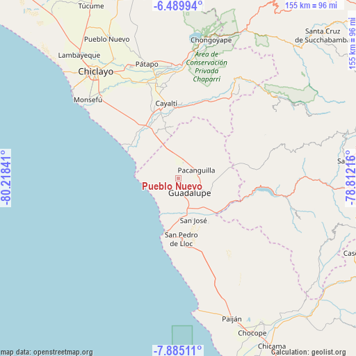
Pueblo Nuevo GPS coordinates[2]
7° 11' 17.016" South, 79° 30' 55.008" West
| Map corner | latitude | longitude |
|---|---|---|
| Upper-left | -6.48994°, | -80.21841° |
| Center: | -7.18806°, | -79.51528° |
| Lower-right: | -7.88511°, | -78.81216° |
| Map W x H: | 155.1×155.1 km | = 96.4×96.4mi |
| max Lat: | -0.96667° ⇑22.2% North |
| Pueblo Nuevo: | -7.18806° |
| min Lat: | ⇓77.8% South -18.01465° |
| min Long | Pueblo Nuevo | max Long |
| -81.30472° | -79.51528° | -69.04167° |
| W 6.6%⇐ | ⇒93.4% E |
Elevation
Elevation of Pueblo Nuevo is 75 m = 246 ft, and this is 2243.7 m = 7361 ft below average elevation for this country.
| Max E: |
5022 m = 16476 ft | 91.2% |
| Avg. | 2318.7 m = 7607 ft | |
| Pueblo Nuevo | 75 m = 246 ft | |
Min E: |
1 m = 3 ft | 8.8% |
See also: Peru elevation on elevation.city.
Geographical zone
Pueblo Nuevo is located in South Torrid zone (between Equator and Tropic of Capricorn). Distance of Equator is 799.2 km =496.6 mi to North.| Distance of | km | miles | from Pueblo Nuevo |
|---|---|---|---|
| Equator | 799.2 | 496.6 | to North |
| Tropic Capricorn | 1806.7 | 1122.6 | to South |
| Antarctic Circle | 6601.9 | 4102.2 | to South |
| South Pole | 9207.8 | 5721.5 | to South |


Nearby cities:
15 places around Pueblo Nuevo: (largest is in red/bold)
• Chepén
10.8 km =6.7 mi,  112°
112°
• Eten
49.5 km =30.8 mi,  308°
308°
• Guadalupe
7.7 km =4.8 mi,  152°
152°
• Mocupe
24.9 km =15.5 mi,  332°
332°
• Nanchoc
39.4 km =24.5 mi,  49°
49°
• Niepos
51.6 km =32.1 mi,  55°
55°
• Nueva Arica
39.9 km =24.8 mi,  28°
28°
• Oyotún
44.9 km =27.9 mi, 31°
• Pacanga
2.9 km =1.8 mi,  35°
35°
• Pacasmayo
24.4 km =15.2 mi,  194°
194°
• Reque
49 km =30.4 mi,  317°
317°
• San Gregorio
48.3 km =30 mi,  71°
71°
• San Pedro de Lloc
26.8 km =16.7 mi,  177°
177°
• Saña
30.8 km =19.1 mi,  346°
346°
• Tembladera
41.2 km =25.6 mi,  102°
102°
Sources, notices
• [Note1] Compared only with cities in Peru existing in our database
• [Src1] Map data: © OpenStreetMap contributors (CC-BY-SA)
• [Src2] Other city data from geonames.org with taken over terms of usage.
• [Src3] Geographical zone / Annual Mean Temperature by Robert A. Rohde @ Wikipedia
