Mocupe geodata
Mocupe (Lambayeque) is a seat of a third-order administrative division; located in Peru in America/Lima (GMT-5) time zone. In our database, there are 305 cities with bigger population. Compared to other cities in Peru, 79.5% of cities are located further ↓South; 93.9% of cities are located further →East and 94.2% of cities have higher elevation than Mocupe. Note1


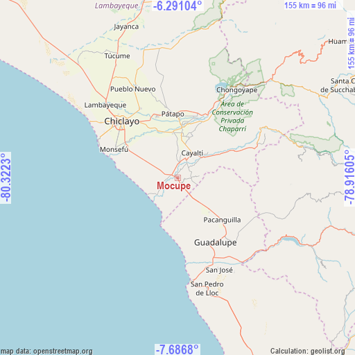
Mocupe GPS coordinates[2]
6° 59' 21.984" South, 79° 37' 9.012" West
| Map corner | latitude | longitude |
|---|---|---|
| Upper-left | -6.29104°, | -80.3223° |
| Center: | -6.98944°, | -79.61917° |
| Lower-right: | -7.6868°, | -78.91605° |
| Map W x H: | 155.2×155.2 km | = 96.4×96.4mi |
| max Lat: | -0.96667° ⇑20.5% North |
| Mocupe: | -6.98944° |
| min Lat: | ⇓79.5% South -18.01465° |
| min Long | Mocupe | max Long |
| -81.30472° | -79.61917° | -69.04167° |
| W 6.1%⇐ | ⇒93.9% E |
Elevation
Elevation of Mocupe is 34 m = 112 ft, and this is 2284.7 m = 7496 ft below average elevation for this country.
| Max E: |
5022 m = 16476 ft | 94.2% |
| Avg. | 2318.7 m = 7607 ft | |
| Mocupe | 34 m = 112 ft | |
Min E: |
1 m = 3 ft | 5.8% |
See also: Peru elevation on elevation.city.
Geographical zone
Mocupe is located in South Torrid zone (between Equator and Tropic of Capricorn). Distance of Equator is 777.2 km =482.9 mi to North.| Distance of | km | miles | from Mocupe |
|---|---|---|---|
| Equator | 777.2 | 482.9 | to North |
| Tropic Capricorn | 1828.8 | 1136.4 | to South |
| Antarctic Circle | 6624 | 4116 | to South |
| South Pole | 9229.9 | 5735.2 | to South |


Nearby cities:
15 places around Mocupe: (largest is in red/bold)
• Chepén
33.8 km =21 mi,  140°
140°
• Chiclayo
34.5 km =21.4 mi,  314°
314°
• Eten
28.5 km =17.7 mi,  288°
288°
• Guadalupe
32.6 km =20.3 mi,  152°
152°
• Monsefú
30.4 km =18.9 mi, 294°
• Nueva Arica
33.2 km =20.6 mi,  66°
66°
• Pacanga
23.7 km =14.7 mi, 146°
• Picsi
34.5 km =21.4 mi,  331°
331°
• Pomalca
30.2 km =18.8 mi,  324°
324°
• Pueblo Nuevo
24.9 km =15.5 mi, 152°
• Reque
25.9 km =16.1 mi,  302°
302°
• San José
36.2 km =22.5 mi, 320°
• Santa Rosa
34.5 km =21.4 mi, 318°
• Santa Rosa
35.3 km =21.9 mi, 289°
• Saña
8.9 km =5.5 mi,  27°
27°
Sources, notices
• [Note1] Compared only with cities in Peru existing in our database
• [Src1] Map data: © OpenStreetMap contributors (CC-BY-SA)
• [Src2] Other city data from geonames.org with taken over terms of usage.
• [Src3] Geographical zone / Annual Mean Temperature by Robert A. Rohde @ Wikipedia
