Salas geodata
Salas (Lambayeque) is a seat of a third-order administrative division; located in Peru in America/Lima (GMT-5) time zone. In our database, there are 305 cities with bigger population. Compared to other cities in Peru, 87.5% of cities are located further ↓South; 93.8% of cities are located further →East and 85.5% of cities have higher elevation than Salas. Note1


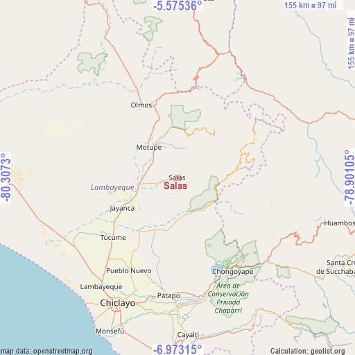
Salas GPS coordinates[2]
6° 16' 28.992" South, 79° 36' 15.012" West
| Map corner | latitude | longitude |
|---|---|---|
| Upper-left | -5.57536°, | -80.3073° |
| Center: | -6.27472°, | -79.60417° |
| Lower-right: | -6.97315°, | -78.90105° |
| Map W x H: | 155.4×155.4 km | = 96.6×96.6mi |
| max Lat: | -0.96667° ⇑12.5% North |
| Salas: | -6.27472° |
| min Lat: | ⇓87.5% South -18.01465° |
| min Long | Salas | max Long |
| -81.30472° | -79.60417° | -69.04167° |
| W 6.2%⇐ | ⇒93.8% E |
Elevation
Elevation of Salas is 169 m = 554 ft, and this is 2149.7 m = 7053 ft below average elevation for this country.
| Max E: |
5022 m = 16476 ft | 85.5% |
| Avg. | 2318.7 m = 7607 ft | |
| Salas | 169 m = 554 ft | |
Min E: |
1 m = 3 ft | 14.5% |
See also: Peru elevation on elevation.city.
Geographical zone
Salas is located in South Torrid zone (between Equator and Tropic of Capricorn). Distance of Equator is 697.7 km =433.5 mi to North.| Distance of | km | miles | from Salas |
|---|---|---|---|
| Equator | 697.7 | 433.5 | to North |
| Tropic Capricorn | 1908.2 | 1185.7 | to South |
| Antarctic Circle | 6703.5 | 4165.4 | to South |
| South Pole | 9309.4 | 5784.6 | to South |


Nearby cities:
15 places around Salas: (largest is in red/bold)
• Cañaris
45.3 km =28.1 mi,  55°
55°
• Chongoyape
47.1 km =29.3 mi,  149°
149°
• Ferreñafe
45.3 km =28.1 mi,  206°
206°
• Incahuasi
32 km =19.9 mi,  82°
82°
• Jayanca
27.3 km =17 mi,  241°
241°
• Licupis
43.4 km =27 mi,  112°
112°
• Manuel Antonio Mesones Muro
43.6 km =27.1 mi,  199°
199°
• Miracosta
38.2 km =23.7 mi, 112°
• Mochumí
41.3 km =25.7 mi,  223°
223°
• Motupe
18.3 km =11.4 mi,  318°
318°
• Olmos
35.8 km =22.2 mi,  334°
334°
• Pacora
31.1 km =19.3 mi, 236°
• Picsi
52.5 km =32.6 mi, 200°
• Tocmoche
30.8 km =19.1 mi,  119°
119°
• Túcume
38 km =23.6 mi,  227°
227°
Sources, notices
• [Note1] Compared only with cities in Peru existing in our database
• [Src1] Map data: © OpenStreetMap contributors (CC-BY-SA)
• [Src2] Other city data from geonames.org with taken over terms of usage.
• [Src3] Geographical zone / Annual Mean Temperature by Robert A. Rohde @ Wikipedia
