La Arena geodata
La Arena (Piura) is a seat of a third-order administrative division; located in Peru in America/Lima (GMT-5) time zone. In our database, there are 305 cities with bigger population. Compared to other cities in Peru, 93.7% of cities are located further ↓South; 98.3% of cities are located further →East and 97% of cities have higher elevation than La Arena. Note1


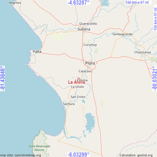
La Arena GPS coordinates[2]
5° 19' 59.988" South, 80° 43' 59.988" West
| Map corner | latitude | longitude |
|---|---|---|
| Upper-left | -4.63287°, | -81.43646° |
| Center: | -5.33333°, | -80.73333° |
| Lower-right: | -6.03299°, | -80.03021° |
| Map W x H: | 155.7×155.7 km | = 96.7×96.7mi |
| max Lat: | -0.96667° ⇑6.3% North |
| La Arena: | -5.33333° |
| min Lat: | ⇓93.7% South -18.01465° |
| min Long | La Arena | max Long |
| -81.30472° | -80.73333° | -69.04167° |
| W 1.7%⇐ | ⇒98.3% E |
Elevation
Elevation of La Arena is 17 m = 56 ft, and this is 2301.7 m = 7552 ft below average elevation for this country.
| Max E: |
5022 m = 16476 ft | 97% |
| Avg. | 2318.7 m = 7607 ft | |
| La Arena | 17 m = 56 ft | |
Min E: |
1 m = 3 ft | 3% |
See also: Peru elevation on elevation.city.
Geographical zone
La Arena is located in South Torrid zone (between Equator and Tropic of Capricorn). Distance of Equator is 593 km =368.5 mi to North.| Distance of | km | miles | from La Arena |
|---|---|---|---|
| Equator | 593 | 368.5 | to North |
| Tropic Capricorn | 2012.9 | 1250.8 | to South |
| Antarctic Circle | 6808.2 | 4230.4 | to South |
| South Pole | 9414.1 | 5849.6 | to South |


Nearby cities:
15 places around La Arena: (largest is in red/bold)
• Bernal
13.1 km =8.1 mi,  188°
188°
• Catacaos
9.3 km =5.8 mi,  36°
36°
• Dos Pueblos
13.5 km =8.4 mi,  195°
195°
• La Huaca
53.2 km =33.1 mi,  331°
331°
• La Unión
7.7 km =4.8 mi, 187°
• Marcavelica
50.7 km =31.5 mi,  3°
3°
• Paita
50.2 km =31.2 mi,  302°
302°
• Piura
19 km =11.8 mi, 35°
• Salinera Colán
49.8 km =30.9 mi,  312°
312°
• Salitral
53.3 km =33.1 mi,  6°
6°
• Sechura
26.7 km =16.6 mi, 201°
• Sinchao
11.8 km =7.3 mi,  141°
141°
• Sojo
48.9 km =30.4 mi,  349°
349°
• Sullana
48 km =29.8 mi, 6°
• Vice
10.8 km =6.7 mi,  210°
210°
Sources, notices
• [Note1] Compared only with cities in Peru existing in our database
• [Src1] Map data: © OpenStreetMap contributors (CC-BY-SA)
• [Src2] Other city data from geonames.org with taken over terms of usage.
• [Src3] Geographical zone / Annual Mean Temperature by Robert A. Rohde @ Wikipedia
