La Unión geodata
La Unión (Piura) is a populated place; located in Peru in America/Lima (GMT-5) time zone. With population of 34,834 people, there are 50 cities with bigger population in this country. Compared to other cities in Peru, 93.4% of cities are located further ↓South; 98.5% of cities are located further →East and 97.4% of cities have higher elevation than La Unión. Note1


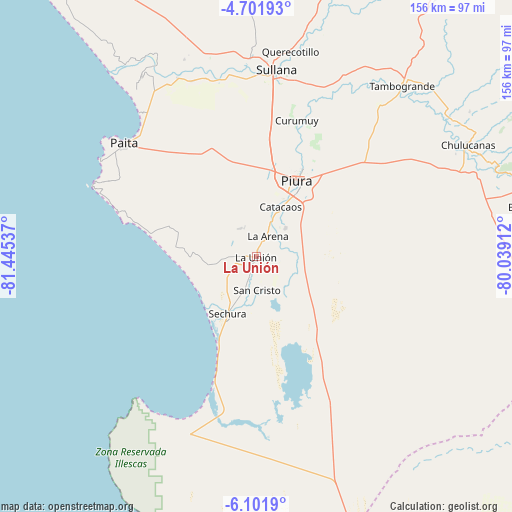
La Unión GPS coordinates[2]
5° 24' 8.352" South, 80° 44' 32.064" West
| Map corner | latitude | longitude |
|---|---|---|
| Upper-left | -4.70193°, | -81.44537° |
| Center: | -5.40232°, | -80.74224° |
| Lower-right: | -6.1019°, | -80.03912° |
| Map W x H: | 155.7×155.7 km | = 96.7×96.7mi |
| max Lat: | -0.96667° ⇑6.6% North |
| La Unión: | -5.40232° |
| min Lat: | ⇓93.4% South -18.01465° |
| min Long | La Unión | max Long |
| -81.30472° | -80.74224° | -69.04167° |
| W 1.5%⇐ | ⇒98.5% E |
Elevation
Elevation of La Unión is 15 m = 49 ft, and this is 2303.7 m = 7558 ft below average elevation for this country.
| Max E: |
5022 m = 16476 ft | 97.4% |
| Avg. | 2318.7 m = 7607 ft | |
| La Unión | 15 m = 49 ft | |
Min E: |
1 m = 3 ft | 2.6% |
See also: Peru elevation on elevation.city.
Geographical zone
La Unión is located in South Torrid zone (between Equator and Tropic of Capricorn). Distance of Equator is 600.7 km =373.3 mi to North.| Distance of | km | miles | from La Unión |
|---|---|---|---|
| Equator | 600.7 | 373.3 | to North |
| Tropic Capricorn | 2005.2 | 1246 | to South |
| Antarctic Circle | 6800.5 | 4225.6 | to South |
| South Pole | 9406.4 | 5844.9 | to South |


Nearby cities:
15 places around La Unión: (largest is in red/bold)
• Bernal
5.4 km =3.4 mi,  189°
189°
• Catacaos
16.4 km =10.2 mi,  23°
23°
• Dos Pueblos
6 km =3.7 mi,  207°
207°
• La Arena
7.7 km =4.8 mi,  7°
7°
• La Huaca
59.6 km =37 mi,  336°
336°
• Marcavelica
58.5 km =36.4 mi,  4°
4°
• Paita
54 km =33.6 mi,  310°
310°
• Piura
26.1 km =16.2 mi,  27°
27°
• Salinera Colán
54.5 km =33.9 mi,  318°
318°
• Salitral
61 km =37.9 mi, 6°
• Sechura
19.3 km =12 mi, 207°
• Sinchao
8.5 km =5.3 mi,  100°
100°
• Sojo
56.4 km =35 mi,  351°
351°
• Sullana
55.8 km =34.7 mi, 6°
• Vice
4.8 km =3 mi,  250°
250°
Sources, notices
• [Note1] Compared only with cities in Peru existing in our database
• [Src1] Map data: © OpenStreetMap contributors (CC-BY-SA)
• [Src2] Other city data from geonames.org with taken over terms of usage.
• [Src3] Geographical zone / Annual Mean Temperature by Robert A. Rohde @ Wikipedia
