Picota geodata
Picota (San Martín) is a seat of a third-order administrative division; located in Peru in America/Lima (GMT-5) time zone. With population of 6,697 people, there are 195 cities with bigger population in this country. Compared to other cities in Peru, 80.3% of cities are located further ↓South; 57.1% of cities are located further →East and 83.4% of cities have higher elevation than Picota. Note1


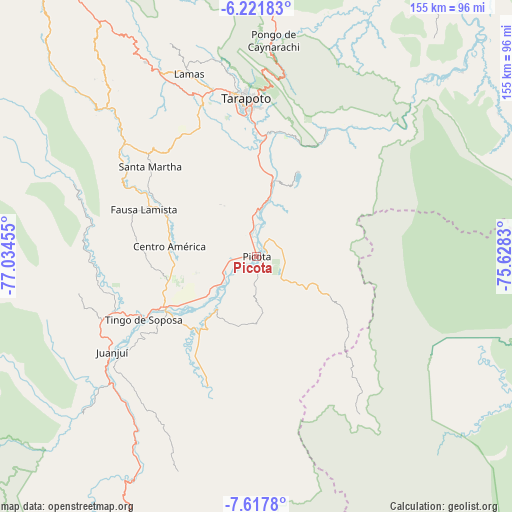
Picota GPS coordinates[2]
6° 55' 13.188" South, 76° 19' 53.112" West
| Map corner | latitude | longitude |
|---|---|---|
| Upper-left | -6.22183°, | -77.03455° |
| Center: | -6.92033°, | -76.33142° |
| Lower-right: | -7.6178°, | -75.6283° |
| Map W x H: | 155.2×155.2 km | = 96.4×96.4mi |
| max Lat: | -0.96667° ⇑19.7% North |
| Picota: | -6.92033° |
| min Lat: | ⇓80.3% South -18.01465° |
| min Long | Picota | max Long |
| -81.30472° | -76.33142° | -69.04167° |
| W 42.9%⇐ | ⇒57.1% E |
Elevation
Elevation of Picota is 223 m = 732 ft, and this is 2095.7 m = 6876 ft below average elevation for this country.
| Max E: |
5022 m = 16476 ft | 83.4% |
| Avg. | 2318.7 m = 7607 ft | |
| Picota | 223 m = 732 ft | |
Min E: |
1 m = 3 ft | 16.6% |
See also: Peru elevation on elevation.city.
Geographical zone
Picota is located in South Torrid zone (between Equator and Tropic of Capricorn). Distance of Equator is 769.5 km =478.1 mi to North.| Distance of | km | miles | from Picota |
|---|---|---|---|
| Equator | 769.5 | 478.1 | to North |
| Tropic Capricorn | 1836.5 | 1141.1 | to South |
| Antarctic Circle | 6631.7 | 4120.7 | to South |
| South Pole | 9237.6 | 5740 | to South |


Nearby cities:
15 places around Picota: (largest is in red/bold)
• Bellavista
32.4 km =20.1 mi,  242°
242°
• Buenos Aires
14.4 km =8.9 mi,  2°
2°
• Caspisapa
10.4 km =6.5 mi,  246°
246°
• Juan Guerra
37.5 km =23.3 mi, 0°
• Pilluana
16.5 km =10.3 mi,  15°
15°
• Pucacaca
7.7 km =4.8 mi,  351°
351°
• Puerto Rico
12.6 km =7.8 mi,  230°
230°
• San Pablo
29.2 km =18.1 mi,  292°
292°
• San Rafael
20 km =12.4 mi, 232°
• Santa Rosa
41.1 km =25.5 mi,  309°
309°
• Sauce
28.5 km =17.7 mi,  26°
26°
• Shamboyacu
24.7 km =15.3 mi,  117°
117°
• Shapaja
38.6 km =24 mi,  11°
11°
• Tres Unidos
16.9 km =10.5 mi,  41°
41°
• Utcurarca
29 km =18 mi, 9°
Sources, notices
• [Note1] Compared only with cities in Peru existing in our database
• [Src1] Map data: © OpenStreetMap contributors (CC-BY-SA)
• [Src2] Other city data from geonames.org with taken over terms of usage.
• [Src3] Geographical zone / Annual Mean Temperature by Robert A. Rohde @ Wikipedia
