Usquil geodata
Usquil (La Libertad) is a seat of a third-order administrative division; located in Peru in America/Lima (GMT-5) time zone. In our database, there are 305 cities with bigger population. Compared to other cities in Peru, 74.9% of cities are located further ↓South; 84.5% of cities are located further →East and 55% of cities have lower elevation than Usquil. Note1


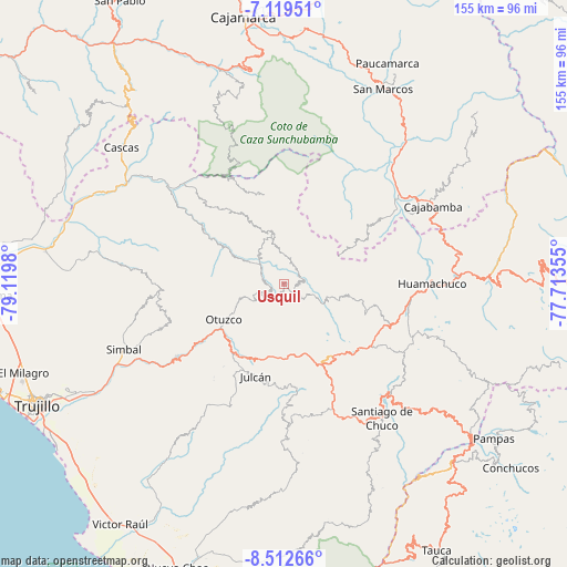
Usquil GPS coordinates[2]
7° 49' 0.012" South, 78° 25' 0.012" West
| Map corner | latitude | longitude |
|---|---|---|
| Upper-left | -7.11951°, | -79.1198° |
| Center: | -7.81667°, | -78.41667° |
| Lower-right: | -8.51266°, | -77.71355° |
| Map W x H: | 154.9×154.9 km | = 96.3×96.3mi |
| max Lat: | -0.96667° ⇑25.1% North |
| Usquil: | -7.81667° |
| min Lat: | ⇓74.9% South -18.01465° |
| min Long | Usquil | max Long |
| -81.30472° | -78.41667° | -69.04167° |
| W 15.5%⇐ | ⇒84.5% E |
Elevation
Elevation of Usquil is 3022 m = 9915 ft, and this is 703.3 m = 2307 ft above average elevation for this country.
| Max E: |
5022 m = 16476 ft | 45% |
| Usquil | 3022 m 9915 ft | |
| Avg. | 2318.7 m = 7607 ft | |
Min E: |
1 m = 3 ft | 55% |
See also: Peru elevation on elevation.city.
Geographical zone
Usquil is located in South Torrid zone (between Equator and Tropic of Capricorn). Distance of Equator is 869.1 km =540 mi to North.| Distance of | km | miles | from Usquil |
|---|---|---|---|
| Equator | 869.1 | 540 | to North |
| Tropic Capricorn | 1736.8 | 1079.2 | to South |
| Antarctic Circle | 6532 | 4058.8 | to South |
| South Pole | 9137.9 | 5678 | to South |


Nearby cities:
15 places around Usquil: (largest is in red/bold)
• Agallpampa
23.6 km =14.7 mi,  218°
218°
• Cachachi
43.3 km =26.9 mi,  19°
19°
• Carabamba
40 km =24.9 mi,  213°
213°
• Charat
4.1 km =2.5 mi,  243°
243°
• Huamachuco
38.6 km =24 mi,  87°
87°
• Huaranchal
15.3 km =9.5 mi,  346°
346°
• La Cuesta
34.9 km =21.7 mi,  251°
251°
• Lucma
25.1 km =15.6 mi,  324°
324°
• Mache
27.3 km =17 mi, 208°
• Marcabal
44.2 km =27.5 mi,  72°
72°
• Otuzco
20.6 km =12.8 mi, 243°
• Quiruvilca
29.1 km =18.1 mi,  124°
124°
• Salpo
30 km =18.6 mi,  227°
227°
• Sayapullo
24.7 km =15.3 mi, 347°
• Sinsicap
38.6 km =24 mi,  267°
267°
Sources, notices
• [Note1] Compared only with cities in Peru existing in our database
• [Src1] Map data: © OpenStreetMap contributors (CC-BY-SA)
• [Src2] Other city data from geonames.org with taken over terms of usage.
• [Src3] Geographical zone / Annual Mean Temperature by Robert A. Rohde @ Wikipedia
