Llama geodata
Llama (Ancash) is a seat of a third-order administrative division; located in Peru in America/Lima (GMT-5) time zone. In our database, there are 305 cities with bigger population. Compared to other cities in Peru, 69.7% of cities are located further ↓South; 70.4% of cities are located further →East and 80.7% of cities have lower elevation than Llama. Note1


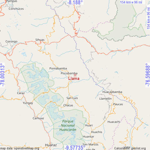
Llama GPS coordinates[2]
8° 52' 59.988" South, 77° 18' 0" West
| Map corner | latitude | longitude |
|---|---|---|
| Upper-left | -8.188°, | -78.00313° |
| Center: | -8.88333°, | -77.3° |
| Lower-right: | -9.57735°, | -76.59688° |
| Map W x H: | 154.5×154.5 km | = 96×96mi |
| max Lat: | -0.96667° ⇑30.3% North |
| Llama: | -8.88333° |
| min Lat: | ⇓69.7% South -18.01465° |
| min Long | Llama | max Long |
| -81.30472° | -77.3° | -69.04167° |
| W 29.6%⇐ | ⇒70.4% E |
Elevation
Elevation of Llama is 3544 m = 11627 ft, and this is 1225.3 m = 4020 ft above average elevation for this country.
| Max E: |
5022 m = 16476 ft | 19.3% |
| Llama | 3544 m 11627 ft | |
| Avg. | 2318.7 m = 7607 ft | |
Min E: |
1 m = 3 ft | 80.7% |
See also: Peru elevation on elevation.city.
Geographical zone
Llama is located in South Torrid zone (between Equator and Tropic of Capricorn). Distance of Equator is 987.7 km =613.7 mi to North.| Distance of | km | miles | from Llama |
|---|---|---|---|
| Equator | 987.7 | 613.7 | to North |
| Tropic Capricorn | 1618.2 | 1005.5 | to South |
| Antarctic Circle | 6413.4 | 3985.1 | to South |
| South Pole | 9019.3 | 5604.3 | to South |


Nearby cities:
15 places around Llama: (largest is in red/bold)
• Aczo
45.3 km =28.1 mi,  131°
131°
• Chacas
40 km =24.9 mi,  193°
193°
• Challas
49.5 km =30.8 mi,  357°
357°
• Chingas
42.9 km =26.7 mi, 127°
• Huacaybamba
41.8 km =26 mi,  114°
114°
• Huacrachuco
35.2 km =21.9 mi,  42°
42°
• Huancaspata
47.4 km =29.5 mi,  0°
0°
• Lucma
13.3 km =8.3 mi,  253°
253°
• Pomabamba
19.1 km =11.9 mi,  286°
286°
• Quinuabamba
18.2 km =11.3 mi,  336°
336°
• San Luis
22.9 km =14.2 mi, 193°
• Sihuas
49.5 km =30.8 mi,  315°
315°
• Ullulluco
49.6 km =30.8 mi, 343°
• Yanama
26.1 km =16.2 mi,  230°
230°
• Yauya
11.1 km =6.9 mi,  180°
180°
Sources, notices
• [Note1] Compared only with cities in Peru existing in our database
• [Src1] Map data: © OpenStreetMap contributors (CC-BY-SA)
• [Src2] Other city data from geonames.org with taken over terms of usage.
• [Src3] Geographical zone / Annual Mean Temperature by Robert A. Rohde @ Wikipedia
