San Luis geodata
San Luis (Ancash) is a seat of a third-order administrative division; located in Peru in America/Lima (GMT-5) time zone. In our database, there are 305 cities with bigger population. Compared to other cities in Peru, 68.4% of cities are located further ↓South; 70.9% of cities are located further →East and 56.7% of cities have lower elevation than San Luis. Note1


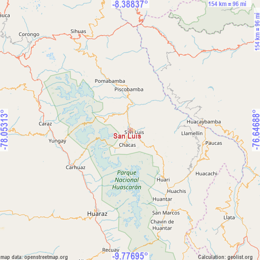
San Luis GPS coordinates[2]
9° 4' 59.988" South, 77° 21' 0" West
| Map corner | latitude | longitude |
|---|---|---|
| Upper-left | -8.38837°, | -78.05313° |
| Center: | -9.08333°, | -77.35° |
| Lower-right: | -9.77695°, | -76.64688° |
| Map W x H: | 154.4×154.4 km | = 95.9×95.9mi |
| max Lat: | -0.96667° ⇑31.6% North |
| San Luis: | -9.08333° |
| min Lat: | ⇓68.4% South -18.01465° |
| min Long | San Luis | max Long |
| -81.30472° | -77.35° | -69.04167° |
| W 29.1%⇐ | ⇒70.9% E |
Elevation
Elevation of San Luis is 3065 m = 10056 ft, and this is 746.3 m = 2448 ft above average elevation for this country.
| Max E: |
5022 m = 16476 ft | 43.3% |
| San Luis | 3065 m 10056 ft | |
| Avg. | 2318.7 m = 7607 ft | |
Min E: |
1 m = 3 ft | 56.7% |
See also: Peru elevation on elevation.city.
Geographical zone
San Luis is located in South Torrid zone (between Equator and Tropic of Capricorn). Distance of Equator is 1010 km =627.6 mi to North.| Distance of | km | miles | from San Luis |
|---|---|---|---|
| Equator | 1010 | 627.6 | to North |
| Tropic Capricorn | 1595.9 | 991.6 | to South |
| Antarctic Circle | 6391.2 | 3971.3 | to South |
| South Pole | 8997.1 | 5590.5 | to South |


Nearby cities:
15 places around San Luis: (largest is in red/bold)
• Aco
39.5 km =24.5 mi,  216°
216°
• Acopampa
37.8 km =23.5 mi,  231°
231°
• Amashca
36.9 km =22.9 mi,  241°
241°
• Carhuaz
39.2 km =24.4 mi, 235°
• Chacas
17.1 km =10.6 mi,  192°
192°
• Chingas
39.6 km =24.6 mi,  95°
95°
• Huari
30.6 km =19 mi,  155°
155°
• Llama
22.9 km =14.2 mi,  13°
13°
• Lucma
19.9 km =12.4 mi,  338°
338°
• Marcara District
38.5 km =23.9 mi, 226°
• Pomabamba
30.6 km =19 mi, 335°
• Quinuabamba
39 km =24.2 mi,  357°
357°
• Shilla
34.4 km =21.4 mi, 241°
• Yanama
15.7 km =9.8 mi,  290°
290°
• Yauya
12.4 km =7.7 mi,  26°
26°
Sources, notices
• [Note1] Compared only with cities in Peru existing in our database
• [Src1] Map data: © OpenStreetMap contributors (CC-BY-SA)
• [Src2] Other city data from geonames.org with taken over terms of usage.
• [Src3] Geographical zone / Annual Mean Temperature by Robert A. Rohde @ Wikipedia
