Yanama geodata
Yanama (Ancash) is a seat of a third-order administrative division; located in Peru in America/Lima (GMT-5) time zone. In our database, there are 305 cities with bigger population. Compared to other cities in Peru, 68.7% of cities are located further ↓South; 72.8% of cities are located further →East and 78.9% of cities have lower elevation than Yanama. Note1


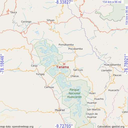
Yanama GPS coordinates[2]
9° 1' 59.988" South, 77° 28' 59.988" West
| Map corner | latitude | longitude |
|---|---|---|
| Upper-left | -8.33827°, | -78.18646° |
| Center: | -9.03333°, | -77.48333° |
| Lower-right: | -9.72705°, | -76.78021° |
| Map W x H: | 154.4×154.4 km | = 95.9×95.9mi |
| max Lat: | -0.96667° ⇑31.3% North |
| Yanama: | -9.03333° |
| min Lat: | ⇓68.7% South -18.01465° |
| min Long | Yanama | max Long |
| -81.30472° | -77.48333° | -69.04167° |
| W 27.2%⇐ | ⇒72.8% E |
Elevation
Elevation of Yanama is 3498 m = 11476 ft, and this is 1179.3 m = 3869 ft above average elevation for this country.
| Max E: |
5022 m = 16476 ft | 21.1% |
| Yanama | 3498 m 11476 ft | |
| Avg. | 2318.7 m = 7607 ft | |
Min E: |
1 m = 3 ft | 78.9% |
See also: Peru elevation on elevation.city.
Geographical zone
Yanama is located in South Torrid zone (between Equator and Tropic of Capricorn). Distance of Equator is 1004.4 km =624.1 mi to North.| Distance of | km | miles | from Yanama |
|---|---|---|---|
| Equator | 1004.4 | 624.1 | to North |
| Tropic Capricorn | 1601.5 | 995.1 | to South |
| Antarctic Circle | 6396.8 | 3974.8 | to South |
| South Pole | 9002.6 | 5594 | to South |


Nearby cities:
15 places around Yanama: (largest is in red/bold)
• Acopampa
32.8 km =20.4 mi,  206°
206°
• Amashca
29.1 km =18.1 mi,  218°
218°
• Carhuaz
32.8 km =20.4 mi, 212°
• Chacas
24.8 km =15.4 mi,  153°
153°
• Llama
26.1 km =16.2 mi,  50°
50°
• Lucma
14.9 km =9.3 mi,  29°
29°
• Mancos
30.7 km =19.1 mi,  235°
235°
• Matacoto
33.3 km =20.7 mi, 241°
• Pomabamba
22.3 km =13.9 mi,  4°
4°
• Ranrahirca
30.4 km =18.9 mi, 239°
• San Luis
15.7 km =9.8 mi,  110°
110°
• Shilla
26.9 km =16.7 mi, 215°
• Shupluy
30.9 km =19.2 mi,  228°
228°
• Yauya
20.9 km =13 mi,  74°
74°
• Yungay
30.9 km =19.2 mi,  247°
247°
Sources, notices
• [Note1] Compared only with cities in Peru existing in our database
• [Src1] Map data: © OpenStreetMap contributors (CC-BY-SA)
• [Src2] Other city data from geonames.org with taken over terms of usage.
• [Src3] Geographical zone / Annual Mean Temperature by Robert A. Rohde @ Wikipedia
