Suyo geodata
Suyo (Piura) is a seat of a third-order administrative division; located in Peru in America/Lima (GMT-5) time zone. In our database, there are 305 cities with bigger population. Compared to other cities in Peru, 97.9% of cities are located further ↓South; 96.7% of cities are located further →East and 79.3% of cities have higher elevation than Suyo. Note1


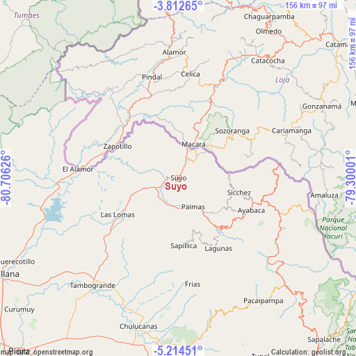
Suyo GPS coordinates[2]
4° 30' 50.112" South, 80° 0' 11.268" West
| Map corner | latitude | longitude |
|---|---|---|
| Upper-left | -3.81265°, | -80.70626° |
| Center: | -4.51392°, | -80.00313° |
| Lower-right: | -5.21451°, | -79.30001° |
| Map W x H: | 155.9×155.9 km | = 96.9×96.9mi |
| max Lat: | -0.96667° ⇑2.1% North |
| Suyo: | -4.51392° |
| min Lat: | ⇓97.9% South -18.01465° |
| min Long | Suyo | max Long |
| -81.30472° | -80.00313° | -69.04167° |
| W 3.3%⇐ | ⇒96.7% E |
Elevation
Elevation of Suyo is 406 m = 1332 ft, and this is 1912.7 m = 6275 ft below average elevation for this country.
| Max E: |
5022 m = 16476 ft | 79.3% |
| Avg. | 2318.7 m = 7607 ft | |
| Suyo | 406 m = 1332 ft | |
Min E: |
1 m = 3 ft | 20.7% |
See also: Peru elevation on elevation.city.
Geographical zone
Suyo is located in South Torrid zone (between Equator and Tropic of Capricorn). Distance of Equator is 501.9 km =311.9 mi to North.| Distance of | km | miles | from Suyo |
|---|---|---|---|
| Equator | 501.9 | 311.9 | to North |
| Tropic Capricorn | 2104 | 1307.4 | to South |
| Antarctic Circle | 6899.3 | 4287 | to South |
| South Pole | 9505.2 | 5906.3 | to South |


Nearby cities:
15 places around Suyo: (largest is in red/bold)
• Ayabaca
34.9 km =21.7 mi,  113°
113°
• Chalaco
62.8 km =39 mi,  158°
158°
• Chulucanas
66.7 km =41.4 mi,  195°
195°
• Frias
46.6 km =29 mi,  172°
172°
• Jilili
24.1 km =15 mi, 108°
• Lagunas
35.3 km =21.9 mi,  150°
150°
• Las Lomas
31.1 km =19.3 mi,  240°
240°
• Montero
23.3 km =14.5 mi,  123°
123°
• Morropón
74.9 km =46.5 mi,  177°
177°
• Pacaipampa
65.1 km =40.5 mi, 145°
• Paimas
14.1 km =8.8 mi, 152°
• Paltashaco
66.5 km =41.3 mi, 168°
• Santo Domingo
58.7 km =36.5 mi, 165°
• Sapillica
29.5 km =18.3 mi, 175°
• Tambo Grande
59.5 km =37 mi,  219°
219°
Sources, notices
• [Note1] Compared only with cities in Peru existing in our database
• [Src1] Map data: © OpenStreetMap contributors (CC-BY-SA)
• [Src2] Other city data from geonames.org with taken over terms of usage.
• [Src3] Geographical zone / Annual Mean Temperature by Robert A. Rohde @ Wikipedia
