Niepos geodata
Niepos (Cajamarca) is a seat of a third-order administrative division; located in Peru in America/Lima (GMT-5) time zone. In our database, there are 305 cities with bigger population. Compared to other cities in Peru, 80.3% of cities are located further ↓South; 91.3% of cities are located further →East and 59.5% of cities have higher elevation than Niepos. Note1


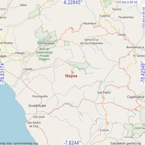
Niepos GPS coordinates[2]
6° 55' 36.984" South, 79° 7' 42.996" West
| Map corner | latitude | longitude |
|---|---|---|
| Upper-left | -6.22845°, | -79.83174° |
| Center: | -6.92694°, | -79.12861° |
| Lower-right: | -7.6244°, | -78.42549° |
| Map W x H: | 155.2×155.2 km | = 96.4×96.4mi |
| max Lat: | -0.96667° ⇑19.7% North |
| Niepos: | -6.92694° |
| min Lat: | ⇓80.3% South -18.01465° |
| min Long | Niepos | max Long |
| -81.30472° | -79.12861° | -69.04167° |
| W 8.7%⇐ | ⇒91.3% E |
Elevation
Elevation of Niepos is 2452 m = 8045 ft, and this is 133.3 m = 437 ft above average elevation for this country.
| Max E: |
5022 m = 16476 ft | 59.5% |
| Niepos | 2452 m 8045 ft | |
| Avg. | 2318.7 m = 7607 ft | |
Min E: |
1 m = 3 ft | 40.5% |
See also: Peru elevation on elevation.city.
Geographical zone
Niepos is located in South Torrid zone (between Equator and Tropic of Capricorn). Distance of Equator is 770.2 km =478.6 mi to North.| Distance of | km | miles | from Niepos |
|---|---|---|---|
| Equator | 770.2 | 478.6 | to North |
| Tropic Capricorn | 1835.7 | 1140.7 | to South |
| Antarctic Circle | 6631 | 4120.3 | to South |
| South Pole | 9236.9 | 5739.5 | to South |


Nearby cities:
15 places around Niepos: (largest is in red/bold)
• Catache
29.9 km =18.6 mi,  20°
20°
• Chilete
45.9 km =28.5 mi,  137°
137°
• Chongoyape
42.9 km =26.7 mi,  317°
317°
• El Prado
18.5 km =11.5 mi,  129°
129°
• La Florida
6.4 km =4 mi,  7°
7°
• Llama
45.9 km =28.5 mi,  1°
1°
• Llapa
35 km =21.7 mi,  100°
100°
• Nanchoc
13.1 km =8.1 mi,  253°
253°
• Nueva Arica
24.4 km =15.2 mi,  284°
284°
• Oyotún
21.1 km =13.1 mi,  295°
295°
• San Bernardino
43.3 km =26.9 mi, 131°
• San Gregorio
14 km =8.7 mi,  167°
167°
• San Pablo
38.8 km =24.1 mi,  122°
122°
• Sexi
41.3 km =25.7 mi, 11°
• Tembladera
37.8 km =23.5 mi,  183°
183°
Sources, notices
• [Note1] Compared only with cities in Peru existing in our database
• [Src1] Map data: © OpenStreetMap contributors (CC-BY-SA)
• [Src2] Other city data from geonames.org with taken over terms of usage.
• [Src3] Geographical zone / Annual Mean Temperature by Robert A. Rohde @ Wikipedia
