Chazuta geodata
Chazuta (San Martín) is a seat of a third-order administrative division; located in Peru in America/Lima (GMT-5) time zone. With population of 8,029 people, there are 168 cities with bigger population in this country. Compared to other cities in Peru, 83.8% of cities are located further ↓South; 54.1% of cities are located further →East and 83.7% of cities have higher elevation than Chazuta. Note1


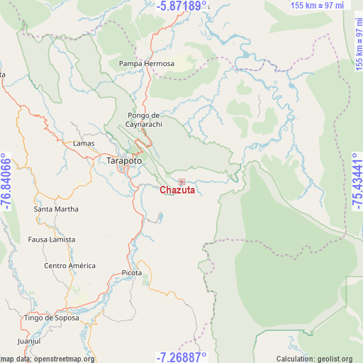
Chazuta GPS coordinates[2]
6° 34' 15.132" South, 76° 8' 15.108" West
| Map corner | latitude | longitude |
|---|---|---|
| Upper-left | -5.87189°, | -76.84066° |
| Center: | -6.57087°, | -76.13753° |
| Lower-right: | -7.26887°, | -75.43441° |
| Map W x H: | 155.3×155.3 km | = 96.5×96.5mi |
| max Lat: | -0.96667° ⇑16.2% North |
| Chazuta: | -6.57087° |
| min Lat: | ⇓83.8% South -18.01465° |
| min Long | Chazuta | max Long |
| -81.30472° | -76.13753° | -69.04167° |
| W 45.9%⇐ | ⇒54.1% E |
Elevation
Elevation of Chazuta is 214 m = 702 ft, and this is 2104.7 m = 6905 ft below average elevation for this country.
| Max E: |
5022 m = 16476 ft | 83.7% |
| Avg. | 2318.7 m = 7607 ft | |
| Chazuta | 214 m = 702 ft | |
Min E: |
1 m = 3 ft | 16.3% |
See also: Peru elevation on elevation.city.
Geographical zone
Chazuta is located in South Torrid zone (between Equator and Tropic of Capricorn). Distance of Equator is 730.6 km =454 mi to North.| Distance of | km | miles | from Chazuta |
|---|---|---|---|
| Equator | 730.6 | 454 | to North |
| Tropic Capricorn | 1875.3 | 1165.3 | to South |
| Antarctic Circle | 6670.6 | 4144.9 | to South |
| South Pole | 9276.4 | 5764.1 | to South |


Nearby cities:
15 places around Chazuta: (largest is in red/bold)
• Barranquita
36.4 km =22.6 mi,  21°
21°
• Buenos Aires
32.2 km =20 mi,  220°
220°
• Cuñumbuqui
38.4 km =23.9 mi,  279°
279°
• Juan Guerra
21.3 km =13.2 mi,  266°
266°
• Lamas
47 km =29.2 mi,  291°
291°
• Picota
44.4 km =27.6 mi,  208°
208°
• Pilluana
28.5 km =17.7 mi, 216°
• Pucacaca
38.5 km =23.9 mi, 215°
• San Antonio
32.7 km =20.3 mi,  314°
314°
• Sauce
15.9 km =9.9 mi, 212°
• Shapaja
13.9 km =8.6 mi, 265°
• Tarapoto
26.3 km =16.3 mi, 287°
• Tres Unidos
28.1 km =17.5 mi,  201°
201°
• Utcurarca
19.4 km =12.1 mi,  238°
238°
• Zapatero
39.5 km =24.5 mi, 276°
Sources, notices
• [Note1] Compared only with cities in Peru existing in our database
• [Src1] Map data: © OpenStreetMap contributors (CC-BY-SA)
• [Src2] Other city data from geonames.org with taken over terms of usage.
• [Src3] Geographical zone / Annual Mean Temperature by Robert A. Rohde @ Wikipedia
