San Antonio geodata
San Antonio (San Martín) is a seat of a third-order administrative division; located in Peru in America/Lima (GMT-5) time zone. In our database, there are 305 cities with bigger population. Compared to other cities in Peru, 86.7% of cities are located further ↓South; 57.4% of cities are located further →East and 73.1% of cities have higher elevation than San Antonio. Note1
Administrative division(s):
- Level 1: San Martín
- Level 2: Provincia de San Martín
- Level 3: San Antonio


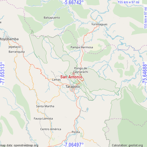
San Antonio GPS coordinates[2]
6° 22' 0.012" South, 76° 21' 0" West
| Map corner | latitude | longitude |
|---|---|---|
| Upper-left | -5.66742°, | -77.05313° |
| Center: | -6.36667°, | -76.35° |
| Lower-right: | -7.06497°, | -75.64688° |
| Map W x H: | 155.4×155.4 km | = 96.6×96.6mi |
| max Lat: | -0.96667° ⇑13.3% North |
| San Antonio: | -6.36667° |
| min Lat: | ⇓86.7% South -18.01465° |
| min Long | San Antonio | max Long |
| -81.30472° | -76.35° | -69.04167° |
| W 42.6%⇐ | ⇒57.4% E |
Elevation
Elevation of San Antonio is 951 m = 3120 ft, and this is 1367.7 m = 4487 ft below average elevation for this country.
| Max E: |
5022 m = 16476 ft | 73.1% |
| Avg. | 2318.7 m = 7607 ft | |
| San Antonio | 951 m = 3120 ft | |
Min E: |
1 m = 3 ft | 26.9% |
See also: Peru elevation on elevation.city.
Geographical zone
San Antonio is located in South Torrid zone (between Equator and Tropic of Capricorn). Distance of Equator is 707.9 km =439.9 mi to North.| Distance of | km | miles | from San Antonio |
|---|---|---|---|
| Equator | 707.9 | 439.9 | to North |
| Tropic Capricorn | 1898 | 1179.4 | to South |
| Antarctic Circle | 6693.3 | 4159 | to South |
| South Pole | 9299.2 | 5778.3 | to South |


Nearby cities:
15 places around San Antonio: (largest is in red/bold)
• Barranquita
38.5 km =23.9 mi,  73°
73°
• Chazuta
32.7 km =20.3 mi,  134°
134°
• Cuñumbuqui
21.5 km =13.4 mi,  221°
221°
• Juan Guerra
24.1 km =15 mi,  174°
174°
• Lamas
21 km =13 mi,  254°
254°
• Pilluana
46.1 km =28.6 mi, 171°
• Santa Rosa
45.9 km =28.5 mi, 219°
• Sauce
39.1 km =24.3 mi,  157°
157°
• Shapaja
25.6 km =15.9 mi, 157°
• Shatoja
44.5 km =27.7 mi, 246°
• Sisa
46.6 km =29 mi,  234°
234°
• Tabalosos
36.9 km =22.9 mi,  272°
272°
• Tarapoto
15.1 km =9.4 mi,  186°
186°
• Utcurarca
33.7 km =20.9 mi, 168°
• Zapatero
24 km =14.9 mi, 220°
Sources, notices
• [Note1] Compared only with cities in Peru existing in our database
• [Src1] Map data: © OpenStreetMap contributors (CC-BY-SA)
• [Src2] Other city data from geonames.org with taken over terms of usage.
• [Src3] Geographical zone / Annual Mean Temperature by Robert A. Rohde @ Wikipedia
