Lamas geodata
Lamas (San Martín) is a seat of a third-order administrative division; located in Peru in America/Lima (GMT-5) time zone. With population of 13,693 people, there are 119 cities with bigger population in this country. Compared to other cities in Peru, 85.7% of cities are located further ↓South; 59.8% of cities are located further →East and 74.6% of cities have higher elevation than Lamas. Note1


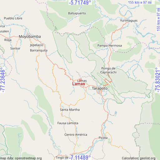
Lamas GPS coordinates[2]
6° 25' 0.012" South, 76° 31' 59.988" West
| Map corner | latitude | longitude |
|---|---|---|
| Upper-left | -5.71749°, | -77.23646° |
| Center: | -6.41667°, | -76.53333° |
| Lower-right: | -7.11489°, | -75.83021° |
| Map W x H: | 155.4×155.4 km | = 96.6×96.6mi |
| max Lat: | -0.96667° ⇑14.3% North |
| Lamas: | -6.41667° |
| min Lat: | ⇓85.7% South -18.01465° |
| min Long | Lamas | max Long |
| -81.30472° | -76.53333° | -69.04167° |
| W 40.2%⇐ | ⇒59.8% E |
Elevation
Elevation of Lamas is 814 m = 2671 ft, and this is 1504.7 m = 4937 ft below average elevation for this country.
| Max E: |
5022 m = 16476 ft | 74.6% |
| Avg. | 2318.7 m = 7607 ft | |
| Lamas | 814 m = 2671 ft | |
Min E: |
1 m = 3 ft | 25.4% |
See also: Peru elevation on elevation.city.
Geographical zone
Lamas is located in South Torrid zone (between Equator and Tropic of Capricorn). Distance of Equator is 713.5 km =443.3 mi to North.| Distance of | km | miles | from Lamas |
|---|---|---|---|
| Equator | 713.5 | 443.3 | to North |
| Tropic Capricorn | 1892.5 | 1175.9 | to South |
| Antarctic Circle | 6687.7 | 4155.5 | to South |
| South Pole | 9293.6 | 5774.8 | to South |


Nearby cities:
15 places around Lamas: (largest is in red/bold)
• Agua Blanca
38.6 km =24 mi,  207°
207°
• Cuñumbuqui
12 km =7.5 mi,  150°
150°
• Juan Guerra
29.1 km =18.1 mi,  129°
129°
• Roque
29.5 km =18.3 mi,  273°
273°
• San Antonio
21 km =13 mi,  74°
74°
• San Pablo
45 km =28 mi,  185°
185°
• Santa Rosa
31 km =19.3 mi,  197°
197°
• Sauce
46.6 km =29 mi, 130°
• Shapaja
35 km =21.7 mi,  121°
121°
• Shatoja
23.9 km =14.9 mi,  238°
238°
• Sisa
27.9 km =17.3 mi,  219°
219°
• Tabalosos
18.2 km =11.3 mi,  294°
294°
• Tarapoto
20.8 km =12.9 mi, 116°
• Utcurarca
38.6 km =24 mi,  135°
135°
• Zapatero
13.4 km =8.3 mi,  160°
160°
Sources, notices
• [Note1] Compared only with cities in Peru existing in our database
• [Src1] Map data: © OpenStreetMap contributors (CC-BY-SA)
• [Src2] Other city data from geonames.org with taken over terms of usage.
• [Src3] Geographical zone / Annual Mean Temperature by Robert A. Rohde @ Wikipedia
