Yanahuanca geodata
Yanahuanca (Pasco) is a populated place; located in Peru in America/Lima (GMT-5) time zone. With population of 5,992 people, there are 209 cities with bigger population in this country. Compared to other cities in Peru, 57.5% of cities are located further ↓South; 59.3% of cities are located further →East and 97.3% of cities have lower elevation than Yanahuanca. Note1


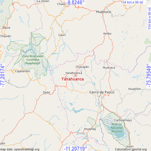
Yanahuanca GPS coordinates[2]
10° 31' 0.012" South, 76° 29' 54.996" West
| Map corner | latitude | longitude |
|---|---|---|
| Upper-left | -9.8246°, | -77.20174° |
| Center: | -10.51667°, | -76.49861° |
| Lower-right: | -11.20719°, | -75.79549° |
| Map W x H: | 153.7×153.7 km | = 95.5×95.5mi |
| max Lat: | -0.96667° ⇑42.5% North |
| Yanahuanca: | -10.51667° |
| min Lat: | ⇓57.5% South -18.01465° |
| min Long | Yanahuanca | max Long |
| -81.30472° | -76.49861° | -69.04167° |
| W 40.7%⇐ | ⇒59.3% E |
Elevation
Elevation of Yanahuanca is 4216 m = 13832 ft, and this is 1897.3 m = 6225 ft above average elevation for this country.
| Max E: |
5022 m = 16476 ft | 2.7% |
| Yanahuanca | 4216 m 13832 ft | |
| Avg. | 2318.7 m = 7607 ft | |
Min E: |
1 m = 3 ft | 97.3% |
See also: Peru elevation on elevation.city.
Geographical zone
Yanahuanca is located in South Torrid zone (between Equator and Tropic of Capricorn). Distance of Equator is 1169.3 km =726.6 mi to North.| Distance of | km | miles | from Yanahuanca |
|---|---|---|---|
| Equator | 1169.3 | 726.6 | to North |
| Tropic Capricorn | 1436.6 | 892.7 | to South |
| Antarctic Circle | 6231.8 | 3872.3 | to South |
| South Pole | 8837.7 | 5491.5 | to South |


Nearby cities:
15 places around Yanahuanca: (largest is in red/bold)
• Cayna
29.8 km =18.5 mi,  23°
23°
• Cerro de Pasco
31.3 km =19.4 mi,  122°
122°
• Chaupimarca
12.8 km =8 mi, 18°
• Colpas
29.1 km =18.1 mi, 18°
• Goyllarisquizga
10.8 km =6.7 mi,  63°
63°
• Huariaca
34.7 km =21.6 mi,  76°
76°
• Mosca
29.8 km =18.5 mi,  49°
49°
• Oyón
34.3 km =21.3 mi,  240°
240°
• Pallanchacra
30.9 km =19.2 mi,  68°
68°
• Paucar
17.3 km =10.7 mi, 20°
• San Rafael
39.8 km =24.7 mi, 60°
• Tinyahuarco
37.1 km =23.1 mi,  138°
138°
• Vilcabamba
7 km =4.3 mi, 52°
• Yanacancha
34.6 km =21.5 mi,  332°
332°
• Yanahuanca
3.4 km =2.1 mi,  324°
324°
Sources, notices
• [Note1] Compared only with cities in Peru existing in our database
• [Src1] Map data: © OpenStreetMap contributors (CC-BY-SA)
• [Src2] Other city data from geonames.org with taken over terms of usage.
• [Src3] Geographical zone / Annual Mean Temperature by Robert A. Rohde @ Wikipedia
