Pallanchacra geodata
Pallanchacra (Pasco) is a seat of a third-order administrative division; located in Peru in America/Lima (GMT-5) time zone. In our database, there are 305 cities with bigger population. Compared to other cities in Peru, 58% of cities are located further ↓South; 55.6% of cities are located further →East and 58.7% of cities have lower elevation than Pallanchacra. Note1


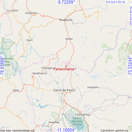
Pallanchacra GPS coordinates[2]
10° 24' 55.008" South, 76° 14' 8.016" West
| Map corner | latitude | longitude |
|---|---|---|
| Upper-left | -9.72299°, | -76.93869° |
| Center: | -10.41528°, | -76.23556° |
| Lower-right: | -11.10604°, | -75.53244° |
| Map W x H: | 153.8×153.8 km | = 95.6×95.6mi |
| max Lat: | -0.96667° ⇑42% North |
| Pallanchacra: | -10.41528° |
| min Lat: | ⇓58% South -18.01465° |
| min Long | Pallanchacra | max Long |
| -81.30472° | -76.23556° | -69.04167° |
| W 44.4%⇐ | ⇒55.6% E |
Elevation
Elevation of Pallanchacra is 3124 m = 10249 ft, and this is 805.3 m = 2642 ft above average elevation for this country.
| Max E: |
5022 m = 16476 ft | 41.3% |
| Pallanchacra | 3124 m 10249 ft | |
| Avg. | 2318.7 m = 7607 ft | |
Min E: |
1 m = 3 ft | 58.7% |
See also: Peru elevation on elevation.city.
Geographical zone
Pallanchacra is located in South Torrid zone (between Equator and Tropic of Capricorn). Distance of Equator is 1158.1 km =719.6 mi to North.| Distance of | km | miles | from Pallanchacra |
|---|---|---|---|
| Equator | 1158.1 | 719.6 | to North |
| Tropic Capricorn | 1447.8 | 899.6 | to South |
| Antarctic Circle | 6243.1 | 3879.3 | to South |
| South Pole | 8849 | 5498.5 | to South |


Nearby cities:
15 places around Pallanchacra: (largest is in red/bold)
• Ambo
31.8 km =19.8 mi,  6°
6°
• Cayna
23.2 km =14.4 mi,  313°
313°
• Cerro de Pasco
28.1 km =17.5 mi,  184°
184°
• Chaupimarca
24.7 km =15.3 mi,  272°
272°
• Colpas
25.4 km =15.8 mi, 309°
• Goyllarisquizga
20.1 km =12.5 mi,  251°
251°
• Huacar
28.4 km =17.6 mi,  359°
359°
• Huariaca
5.8 km =3.6 mi,  120°
120°
• Mosca
10.1 km =6.3 mi,  322°
322°
• Paucar
23.3 km =14.5 mi,  282°
282°
• San Rafael
10.3 km =6.4 mi,  33°
33°
• Tomay Kichwa
37.7 km =23.4 mi,  3°
3°
• Vilcabamba
24.2 km =15 mi, 253°
• Yanahuanca
30.9 km =19.2 mi, 248°
• Yanahuanca
31.9 km =19.8 mi, 254°
Sources, notices
• [Note1] Compared only with cities in Peru existing in our database
• [Src1] Map data: © OpenStreetMap contributors (CC-BY-SA)
• [Src2] Other city data from geonames.org with taken over terms of usage.
• [Src3] Geographical zone / Annual Mean Temperature by Robert A. Rohde @ Wikipedia
