Yanacancha geodata
Yanacancha (Huanuco) is a populated place; located in Peru in America/Lima (GMT-5) time zone. With population of 23,175 people, there are 76 cities with bigger population in this country. Compared to other cities in Peru, 59.5% of cities are located further ↓South; 61.1% of cities are located further →East and 94.4% of cities have lower elevation than Yanacancha. Note1


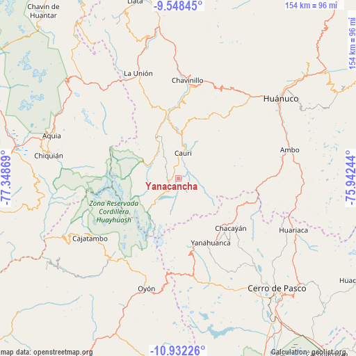
Yanacancha GPS coordinates[2]
10° 14' 27.996" South, 76° 38' 44.016" West
| Map corner | latitude | longitude |
|---|---|---|
| Upper-left | -9.54845°, | -77.34869° |
| Center: | -10.24111°, | -76.64556° |
| Lower-right: | -10.93226°, | -75.94244° |
| Map W x H: | 153.9×153.9 km | = 95.6×95.6mi |
| max Lat: | -0.96667° ⇑40.5% North |
| Yanacancha: | -10.24111° |
| min Lat: | ⇓59.5% South -18.01465° |
| min Long | Yanacancha | max Long |
| -81.30472° | -76.64556° | -69.04167° |
| W 38.9%⇐ | ⇒61.1% E |
Elevation
Elevation of Yanacancha is 3997 m = 13114 ft, and this is 1678.3 m = 5506 ft above average elevation for this country.
| Max E: |
5022 m = 16476 ft | 5.6% |
| Yanacancha | 3997 m 13114 ft | |
| Avg. | 2318.7 m = 7607 ft | |
Min E: |
1 m = 3 ft | 94.4% |
See also: Peru elevation on elevation.city.
Geographical zone
Yanacancha is located in South Torrid zone (between Equator and Tropic of Capricorn). Distance of Equator is 1138.7 km =707.6 mi to North.| Distance of | km | miles | from Yanacancha |
|---|---|---|---|
| Equator | 1138.7 | 707.6 | to North |
| Tropic Capricorn | 1467.2 | 911.7 | to South |
| Antarctic Circle | 6262.5 | 3891.3 | to South |
| South Pole | 8868.4 | 5510.6 | to South |


Nearby cities:
15 places around Yanacancha: (largest is in red/bold)
• Baños
20.8 km =12.9 mi,  331°
331°
• Cauri
11.3 km =7 mi,  11°
11°
• Cayna
28.3 km =17.6 mi,  96°
96°
• Chaupimarca
27.3 km =17 mi,  132°
132°
• Colpas
25.5 km =15.8 mi, 96°
• Goyllarisquizga
36.6 km =22.7 mi,  135°
135°
• Jivia
24.4 km =15.2 mi,  351°
351°
• Margos
29.4 km =18.3 mi,  27°
27°
• Paucar
26.4 km =16.4 mi,  123°
123°
• Queropalca
18.6 km =11.6 mi,  290°
290°
• Rondos
29 km =18 mi, 350°
• San Miguel de Cauri
11.7 km =7.3 mi, 12°
• Vilcabamba
34.1 km =21.2 mi, 140°
• Yanahuanca
31.2 km =19.4 mi,  153°
153°
• Yanahuanca
34.6 km =21.5 mi, 152°
Sources, notices
• [Note1] Compared only with cities in Peru existing in our database
• [Src1] Map data: © OpenStreetMap contributors (CC-BY-SA)
• [Src2] Other city data from geonames.org with taken over terms of usage.
• [Src3] Geographical zone / Annual Mean Temperature by Robert A. Rohde @ Wikipedia
