Colpas geodata
Colpas (Huanuco) is a seat of a third-order administrative division; located in Peru in America/Lima (GMT-5) time zone. In our database, there are 305 cities with bigger population. Compared to other cities in Peru, 59.4% of cities are located further ↓South; 58.2% of cities are located further →East and 54.6% of cities have higher elevation than Colpas. Note1


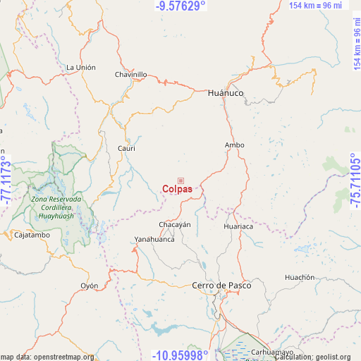
Colpas GPS coordinates[2]
10° 16' 8.004" South, 76° 24' 51.012" West
| Map corner | latitude | longitude |
|---|---|---|
| Upper-left | -9.57629°, | -77.1173° |
| Center: | -10.26889°, | -76.41417° |
| Lower-right: | -10.95998°, | -75.71105° |
| Map W x H: | 153.9×153.9 km | = 95.6×95.6mi |
| max Lat: | -0.96667° ⇑40.6% North |
| Colpas: | -10.26889° |
| min Lat: | ⇓59.4% South -18.01465° |
| min Long | Colpas | max Long |
| -81.30472° | -76.41417° | -69.04167° |
| W 41.8%⇐ | ⇒58.2% E |
Elevation
Elevation of Colpas is 2693 m = 8835 ft, and this is 374.3 m = 1228 ft above average elevation for this country.
| Max E: |
5022 m = 16476 ft | 54.6% |
| Colpas | 2693 m 8835 ft | |
| Avg. | 2318.7 m = 7607 ft | |
Min E: |
1 m = 3 ft | 45.4% |
See also: Peru elevation on elevation.city.
Geographical zone
Colpas is located in South Torrid zone (between Equator and Tropic of Capricorn). Distance of Equator is 1141.8 km =709.5 mi to North.| Distance of | km | miles | from Colpas |
|---|---|---|---|
| Equator | 1141.8 | 709.5 | to North |
| Tropic Capricorn | 1464.1 | 909.7 | to South |
| Antarctic Circle | 6259.4 | 3889.4 | to South |
| South Pole | 8865.3 | 5508.6 | to South |


Nearby cities:
15 places around Colpas: (largest is in red/bold)
• Ambo
27.6 km =17.1 mi,  56°
56°
• Cauri
27 km =16.8 mi,  301°
301°
• Cayna
2.8 km =1.7 mi,  96°
96°
• Chaupimarca
16.2 km =10.1 mi,  198°
198°
• Goyllarisquizga
22.8 km =14.2 mi,  178°
178°
• Huacar
22.8 km =14.2 mi, 58°
• Mosca
15.7 km =9.8 mi,  121°
121°
• Pallanchacra
25.4 km =15.8 mi,  129°
129°
• Paucar
11.8 km =7.3 mi, 195°
• San Miguel de Cauri
27.1 km =16.8 mi, 302°
• San Rafael
26.4 km =16.4 mi,  106°
106°
• Vilcabamba
23.5 km =14.6 mi,  188°
188°
• Yanacancha
25.5 km =15.8 mi,  276°
276°
• Yanahuanca
27.2 km =16.9 mi, 204°
• Yanahuanca
29.1 km =18.1 mi, 198°
Sources, notices
• [Note1] Compared only with cities in Peru existing in our database
• [Src1] Map data: © OpenStreetMap contributors (CC-BY-SA)
• [Src2] Other city data from geonames.org with taken over terms of usage.
• [Src3] Geographical zone / Annual Mean Temperature by Robert A. Rohde @ Wikipedia
