Oyón geodata
Oyón (Lima region) is a populated place; located in Peru in America/Lima (GMT-5) time zone. With population of 6,276 people, there are 202 cities with bigger population in this country. Compared to other cities in Peru, 57% of cities are located further ↓South; 64% of cities are located further →East and 83.7% of cities have lower elevation than Oyón. Note1


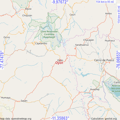
Oyón GPS coordinates[2]
10° 40' 6.456" South, 76° 46' 17.94" West
| Map corner | latitude | longitude |
|---|---|---|
| Upper-left | -9.97672°, | -77.47478° |
| Center: | -10.66846°, | -76.77165° |
| Lower-right: | -11.35863°, | -76.06853° |
| Map W x H: | 153.7×153.7 km | = 95.5×95.5mi |
| max Lat: | -0.96667° ⇑43% North |
| Oyón: | -10.66846° |
| min Lat: | ⇓57% South -18.01465° |
| min Long | Oyón | max Long |
| -81.30472° | -76.77165° | -69.04167° |
| W 36%⇐ | ⇒64% E |
Elevation
Elevation of Oyón is 3617 m = 11867 ft, and this is 1298.3 m = 4260 ft above average elevation for this country.
| Max E: |
5022 m = 16476 ft | 16.3% |
| Oyón | 3617 m 11867 ft | |
| Avg. | 2318.7 m = 7607 ft | |
Min E: |
1 m = 3 ft | 83.7% |
See also: Peru elevation on elevation.city.
Geographical zone
Oyón is located in South Torrid zone (between Equator and Tropic of Capricorn). Distance of Equator is 1186.2 km =737.1 mi to North.| Distance of | km | miles | from Oyón |
|---|---|---|---|
| Equator | 1186.2 | 737.1 | to North |
| Tropic Capricorn | 1419.7 | 882.2 | to South |
| Antarctic Circle | 6215 | 3861.8 | to South |
| South Pole | 8820.8 | 5481 | to South |


Nearby cities:
15 places around Oyón: (largest is in red/bold)
• Andajes
20.4 km =12.7 mi,  227°
227°
• Caujul
27.3 km =17 mi,  236°
236°
• Chaupimarca
44.6 km =27.7 mi,  49°
49°
• Copa
45.9 km =28.5 mi,  312°
312°
• Gorgor
30.1 km =18.7 mi,  288°
288°
• Goyllarisquizga
45.1 km =28 mi,  61°
61°
• Jucul
31.3 km =19.4 mi,  174°
174°
• Mangas
48.7 km =30.3 mi, 312°
• Maray
30.5 km =19 mi,  192°
192°
• Paccho
36.6 km =22.7 mi,  208°
208°
• Paucar
48.8 km =30.3 mi, 47°
• Santa Cruz
46.9 km =29.1 mi,  201°
201°
• Vilcabamba
41.3 km =25.7 mi, 59°
• Yanahuanca
34.1 km =21.2 mi, 54°
• Yanahuanca
34.3 km =21.3 mi, 60°
Sources, notices
• [Note1] Compared only with cities in Peru existing in our database
• [Src1] Map data: © OpenStreetMap contributors (CC-BY-SA)
• [Src2] Other city data from geonames.org with taken over terms of usage.
• [Src3] Geographical zone / Annual Mean Temperature by Robert A. Rohde @ Wikipedia
