Ventanilla geodata
Ventanilla (Callao) is a seat of a third-order administrative division; located in Peru in America/Lima (GMT-5) time zone. In our database, there are 305 cities with bigger population. Compared to other cities in Peru, 51.5% of cities are located further ↑North; 68.6% of cities are located further →East and 88.1% of cities have higher elevation than Ventanilla. Note1


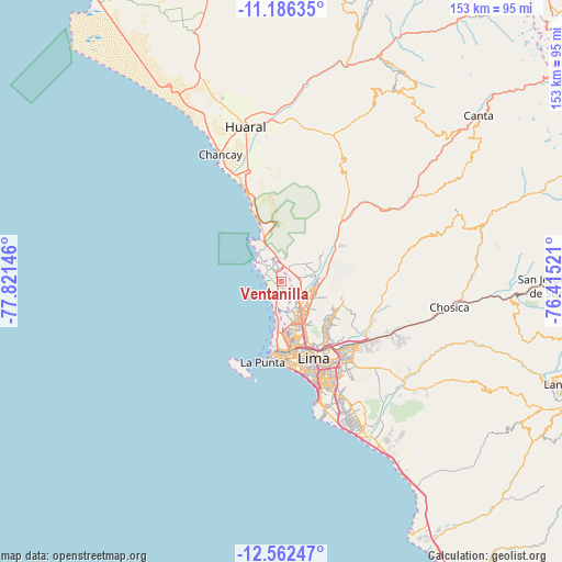
Ventanilla GPS coordinates[2]
11° 52' 31.008" South, 77° 7' 5.988" West
| Map corner | latitude | longitude |
|---|---|---|
| Upper-left | -11.18635°, | -77.82146° |
| Center: | -11.87528°, | -77.11833° |
| Lower-right: | -12.56247°, | -76.41521° |
| Map W x H: | 153×153 km | = 95.1×95.1mi |
| max Lat: | -0.96667° ⇑51.5% North |
| Ventanilla: | -11.87528° |
| min Lat: | ⇓48.5% South -18.01465° |
| min Long | Ventanilla | max Long |
| -81.30472° | -77.11833° | -69.04167° |
| W 31.4%⇐ | ⇒68.6% E |
Elevation
Elevation of Ventanilla is 128 m = 420 ft, and this is 2190.7 m = 7187 ft below average elevation for this country.
| Max E: |
5022 m = 16476 ft | 88.1% |
| Avg. | 2318.7 m = 7607 ft | |
| Ventanilla | 128 m = 420 ft | |
Min E: |
1 m = 3 ft | 11.9% |
See also: Peru elevation on elevation.city.
Geographical zone
Ventanilla is located in South Torrid zone (between Equator and Tropic of Capricorn). Distance of this Southern Tropic circle is 1285.5 km =798.8 mi to South.| Distance of | km | miles | from Ventanilla |
|---|---|---|---|
| Equator | 1320.4 | 820.5 | to North |
| Tropic Capricorn | 1285.5 | 798.8 | to South |
| Antarctic Circle | 6080.8 | 3778.4 | to South |
| South Pole | 8686.7 | 5397.7 | to South |


Nearby cities:
15 places around Ventanilla: (largest is in red/bold)
• Aucallama
36 km =22.4 mi,  349°
349°
• Callao
20.2 km =12.6 mi,  179°
179°
• Carabayllo
9.1 km =5.7 mi,  74°
74°
• Chancay
37.5 km =23.3 mi,  334°
334°
• Independencia
15 km =9.3 mi,  148°
148°
• La Molina
29.5 km =18.3 mi,  141°
141°
• Lima
21.1 km =13.1 mi, 152°
• San Isidro
27.8 km =17.3 mi,  164°
164°
• San Luis
26.1 km =16.2 mi, 148°
• Santa María
28.4 km =17.6 mi,  120°
120°
• Santa Rosa
10.4 km =6.5 mi,  324°
324°
• Santiago de Surco
31.4 km =19.5 mi, 157°
• Urb. Santo Domingo
9.2 km =5.7 mi,  90°
90°
• Vitarte
26.7 km =16.6 mi,  131°
131°
• Yangas
35.8 km =22.2 mi,  55°
55°
Sources, notices
• [Note1] Compared only with cities in Peru existing in our database
• [Src1] Map data: © OpenStreetMap contributors (CC-BY-SA)
• [Src2] Other city data from geonames.org with taken over terms of usage.
• [Src3] Geographical zone / Annual Mean Temperature by Robert A. Rohde @ Wikipedia
