Santa Rosa geodata
Santa Rosa (Lima region) is a seat of a third-order administrative division; located in Peru in America/Lima (GMT-5) time zone. In our database, there are 305 cities with bigger population. Compared to other cities in Peru, 50.4% of cities are located further ↑North; 69.3% of cities are located further →East and 94.9% of cities have higher elevation than Santa Rosa. Note1


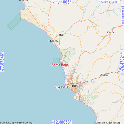
Santa Rosa GPS coordinates[2]
11° 47' 57.012" South, 77° 10' 23.988" West
| Map corner | latitude | longitude |
|---|---|---|
| Upper-left | -11.11005°, | -77.87646° |
| Center: | -11.79917°, | -77.17333° |
| Lower-right: | -12.48656°, | -76.47021° |
| Map W x H: | 153.1×153.1 km | = 95.1×95.1mi |
| max Lat: | -0.96667° ⇑50.4% North |
| Santa Rosa: | -11.79917° |
| min Lat: | ⇓49.6% South -18.01465° |
| min Long | Santa Rosa | max Long |
| -81.30472° | -77.17333° | -69.04167° |
| W 30.7%⇐ | ⇒69.3% E |
Elevation
Elevation of Santa Rosa is 31 m = 102 ft, and this is 2287.7 m = 7506 ft below average elevation for this country.
| Max E: |
5022 m = 16476 ft | 94.9% |
| Avg. | 2318.7 m = 7607 ft | |
| Santa Rosa | 31 m = 102 ft | |
Min E: |
1 m = 3 ft | 5.1% |
See also: Peru elevation on elevation.city.
Geographical zone
Santa Rosa is located in South Torrid zone (between Equator and Tropic of Capricorn). Distance of this Southern Tropic circle is 1294 km =804.1 mi to South.| Distance of | km | miles | from Santa Rosa |
|---|---|---|---|
| Equator | 1311.9 | 815.2 | to North |
| Tropic Capricorn | 1294 | 804.1 | to South |
| Antarctic Circle | 6089.2 | 3783.7 | to South |
| South Pole | 8695.1 | 5402.9 | to South |


Nearby cities:
15 places around Santa Rosa: (largest is in red/bold)
• Aucallama
26.9 km =16.7 mi,  358°
358°
• Callao
29.2 km =18.1 mi,  168°
168°
• Carabayllo
15.9 km =9.9 mi,  112°
112°
• Chancay
27.3 km =17 mi,  338°
338°
• Huaral
34 km =21.1 mi,  353°
353°
• Independencia
25.4 km =15.8 mi,  146°
146°
• La Molina
39.9 km =24.8 mi,  142°
142°
• Lima
31.4 km =19.5 mi, 149°
• San Isidro
37.8 km =23.5 mi,  159°
159°
• San Luis
36.5 km =22.7 mi, 147°
• Santa María
38.1 km =23.7 mi,  126°
126°
• Urb. Santo Domingo
17.5 km =10.9 mi,  119°
119°
• Ventanilla
10.4 km =6.5 mi, 144°
• Vitarte
36.9 km =22.9 mi, 134°
• Yangas
37.5 km =23.3 mi,  72°
72°
Sources, notices
• [Note1] Compared only with cities in Peru existing in our database
• [Src1] Map data: © OpenStreetMap contributors (CC-BY-SA)
• [Src2] Other city data from geonames.org with taken over terms of usage.
• [Src3] Geographical zone / Annual Mean Temperature by Robert A. Rohde @ Wikipedia
