Independencia geodata
Independencia (Lima region) is a populated locality; located in Peru in America/Lima (GMT-5) time zone. With population of 3,987 people, there are 269 cities with bigger population in this country. Compared to other cities in Peru, 53.2% of cities are located further ↑North; 67.8% of cities are located further →East and 85.8% of cities have higher elevation than Independencia. Note1


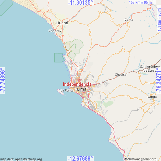
Independencia GPS coordinates[2]
11° 59' 24" South, 77° 2' 44.988" West
| Map corner | latitude | longitude |
|---|---|---|
| Upper-left | -11.30135°, | -77.74896° |
| Center: | -11.99°, | -77.04583° |
| Lower-right: | -12.67689°, | -76.34271° |
| Map W x H: | 152.9×152.9 km | = 95×95mi |
| max Lat: | -0.96667° ⇑53.2% North |
| Independencia: | -11.99° |
| min Lat: | ⇓46.8% South -18.01465° |
| min Long | Independencia | max Long |
| -81.30472° | -77.04583° | -69.04167° |
| W 32.2%⇐ | ⇒67.8% E |
Elevation
Elevation of Independencia is 164 m = 538 ft, and this is 2154.7 m = 7069 ft below average elevation for this country.
| Max E: |
5022 m = 16476 ft | 85.8% |
| Avg. | 2318.7 m = 7607 ft | |
| Independencia | 164 m = 538 ft | |
Min E: |
1 m = 3 ft | 14.2% |
See also: Peru elevation on elevation.city.
Geographical zone
Independencia is located in South Torrid zone (between Equator and Tropic of Capricorn). Distance of this Southern Tropic circle is 1272.8 km =790.9 mi to South.| Distance of | km | miles | from Independencia |
|---|---|---|---|
| Equator | 1333.2 | 828.4 | to North |
| Tropic Capricorn | 1272.8 | 790.9 | to South |
| Antarctic Circle | 6068 | 3770.5 | to South |
| South Pole | 8673.9 | 5389.7 | to South |


Nearby cities:
15 places around Independencia: (largest is in red/bold)
• Callao
10.8 km =6.7 mi,  226°
226°
• Carabayllo
15.2 km =9.4 mi,  3°
3°
• Chaclacayo
30.3 km =18.8 mi,  88°
88°
• Chosica
37 km =23 mi,  81°
81°
• Cieneguilla
29.6 km =18.4 mi,  122°
122°
• La Molina
14.7 km =9.1 mi,  134°
134°
• Lima
6.2 km =3.9 mi,  162°
162°
• San Isidro
14.1 km =8.8 mi,  181°
181°
• San Luis
11.2 km =7 mi,  149°
149°
• Santa María
16.7 km =10.4 mi,  95°
95°
• Santa Rosa
25.4 km =15.8 mi,  326°
326°
• Santiago de Surco
16.7 km =10.4 mi,  165°
165°
• Urb. Santo Domingo
12.7 km =7.9 mi,  6°
6°
• Ventanilla
15 km =9.3 mi, 328°
• Vitarte
13.1 km =8.1 mi,  111°
111°
Sources, notices
• [Note1] Compared only with cities in Peru existing in our database
• [Src1] Map data: © OpenStreetMap contributors (CC-BY-SA)
• [Src2] Other city data from geonames.org with taken over terms of usage.
• [Src3] Geographical zone / Annual Mean Temperature by Robert A. Rohde @ Wikipedia
