Totoral geodata
Totoral (Tacna) is a populated place; located in Peru in America/Lima (GMT-5) time zone. With population of 1,976 people, there are 298 cities with bigger population in this country. Compared to other cities in Peru, 98.5% of cities are located further ↑North; 93.3% of cities are located further ←West and 65.4% of cities have higher elevation than Totoral. Note1


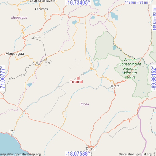
Totoral GPS coordinates[2]
17° 24' 22.32" South, 70° 21' 52.704" West
| Map corner | latitude | longitude |
|---|---|---|
| Upper-left | -16.73405°, | -71.06777° |
| Center: | -17.4062°, | -70.36464° |
| Lower-right: | -18.07588°, | -69.66152° |
| Map W x H: | 149.2×149.2 km | = 92.7×92.7mi |
| max Lat: | -0.96667° ⇑98.5% North |
| Totoral: | -17.4062° |
| min Lat: | ⇓1.5% South -18.01465° |
| min Long | Totoral | max Long |
| -81.30472° | -70.36464° | -69.04167° |
| W 93.3%⇐ | ⇒6.7% E |
Elevation
Elevation of Totoral is 1979 m = 6493 ft, and this is 339.7 m = 1115 ft below average elevation for this country.
| Max E: |
5022 m = 16476 ft | 65.4% |
| Avg. | 2318.7 m = 7607 ft | |
| Totoral | 1979 m = 6493 ft | |
Min E: |
1 m = 3 ft | 34.6% |
See also: Peru elevation on elevation.city.
Geographical zone
Totoral is located in South Torrid zone (between Equator and Tropic of Capricorn). Distance of this Southern Tropic circle is 670.5 km =416.6 mi to South.| Distance of | km | miles | from Totoral |
|---|---|---|---|
| Equator | 1935.4 | 1202.6 | to North |
| Tropic Capricorn | 670.5 | 416.6 | to South |
| Antarctic Circle | 5465.8 | 3396.3 | to South |
| South Pole | 8071.7 | 5015.5 | to South |


Nearby cities:
15 places around Totoral: (largest is in red/bold)
• Cairani
13.4 km =8.3 mi,  0°
0°
• Camilaca
15.4 km =9.6 mi,  354°
354°
• Candarave
19.7 km =12.2 mi,  38°
38°
• Chipispaya
18.7 km =11.6 mi,  123°
123°
• Chucatamani
27 km =16.8 mi,  107°
107°
• Chuquitira
36.5 km =22.7 mi,  69°
69°
• Curibaya
4.1 km =2.5 mi,  50°
50°
• Huanuara
11.2 km =7 mi,  23°
23°
• Ilabaya
15.9 km =9.9 mi,  264°
264°
• Pujocucho
27.7 km =17.2 mi, 2°
• Quilahuani
15 km =9.3 mi, 49°
• Sitajara
24.9 km =15.5 mi,  82°
82°
• Susapaya
25.4 km =15.8 mi, 76°
• Tarata
36 km =22.4 mi,  102°
102°
• Ticaco
34 km =21.1 mi, 97°
Sources, notices
• [Note1] Compared only with cities in Peru existing in our database
• [Src1] Map data: © OpenStreetMap contributors (CC-BY-SA)
• [Src2] Other city data from geonames.org with taken over terms of usage.
• [Src3] Geographical zone / Annual Mean Temperature by Robert A. Rohde @ Wikipedia
